
IMAGES TAKEN NEAR TO
West Street, STAMFORD, PE9 2PN
Introduction
This page details the photographs taken nearby to West Street, PE9 2PN by members of the Geograph project.
The Geograph project started in 2005 with the aim of publishing, organising and preserving representative images for every square kilometre of Great Britain, Ireland and the Isle of Man.

There are currently over 7.5m images from over14,400 individuals and you can help contribute to the project by visiting https://www.geograph.org.uk
Image Map
Images are licensed for reuse under creativecommons.org/licenses/by-sa/2.0
Notes
- Clicking on the map will re-center to the selected point.
- The higher the marker number, the further away the image location is from the centre of the postcode.
Image Listing (658 Images Found)
Images are licensed for reuse under creativecommons.org/licenses/by-sa/2.0
Image
Details
Distance
1

The Jolly Brewer
Lots to be Jolly about, the feed in tariff should be maxed out from the solar panels on a bright crisp winters day.
Image: © Michael Trolove
Taken: 3 Feb 2012
0.04 miles
2

The Jolly Brewer, Stamford
The Jolly Brewer stands at the junction of West Street and Foundry Road. The pub dates from 1830. The owners also run a microbrewery at Ketton, the Baker's Dozen Brewing Co, whose products are normally on sale here.
Image: © Stephen McKay
Taken: 24 Jun 2016
0.04 miles
3

West Street, Stamford
Looking out of the town along the A6121 with Foundry Road on the right.
Image: © Stephen McKay
Taken: 24 Jun 2016
0.04 miles
4

Stamford Telephone Exchange, Lincs
Situated in Foundry Road, this TE serves the market town of Stamford plus Belmesthorpe, Easton On The Hill, Essendine, Great Casterton, Little Casterton, Ryhall, Tickencote, Tinwell and Uffington nearby. A BT Openreach van can be seen parked in front of the TE, which has mobile phone aerials on its roof. The postcode of this TE is PE9 2PP.
Image: © David Hillas
Taken: 25 Apr 2015
0.05 miles
5
![Stamford features [3]](https://s1.geograph.org.uk/geophotos/07/13/37/7133701_614b8b12_120x120.jpg)
Stamford features [3]
At the junction of Petergate and West Street stands a tower of the medieval walls. Constructed of three stages of coursed rubble stone. Listed, grade I, with details at: https://historicengland.org.uk/listing/the-list/list-entry/1360072 A Scheduled Ancient Monument with details at: https://historicengland.org.uk/listing/the-list/list-entry/1005007
Stamford is a market town on the southern border of Lincolnshire, located at the lowest point that the River Welland could be forded. It is some 11 miles northwest of Peterborough and about 27 miles east of Leicester, and is set on Roman Ermine Street and the Great North Road. The picturesque town is constructed almost entirely of limestone, much of the town centre was built in the 17th and 18th centuries in Jacobean or Georgian style. Tourism is an important element of Stamford’s economy.
Image: © Michael Dibb
Taken: 26 Sep 2021
0.05 miles
6

West Tower
The last remaining defence tower near St. Peter's Gate
Image: © Kim Fyson
Taken: 28 Jun 2014
0.06 miles
7

Bastion, Petergate, Stamford
The town walls, formerly bank and palisade, were strengthened with masonry in the 13th/14th centuries. Listed Grade II and Scheduled Monument
Image: © Alan Murray-Rust
Taken: 27 Dec 2019
0.06 miles
8

The West Tower in Stamford, Lincolnshire
The West Tower or bastion is the last remaining tower to protect the town from invasion by way of St Peter's gate which stood nearby
Image: © Richard Humphrey
Taken: 26 Feb 2017
0.06 miles
9

St Peter's Street junction
There is an OS benchmark Image on the corner of the building
Image: © Roger Templeman
Taken: 21 May 2015
0.07 miles
10
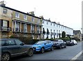
Rutland Terrace, Stamford
Early 19th century Regency-style terrace with decorative Greek motifs and cast iron balconies, built 1829-31, Listed Grade II. The eastern section, mainly in stucco.
Image: © Alan Murray-Rust
Taken: 27 Dec 2019
0.07 miles