
IMAGES TAKEN NEAR TO
Anseres Place, STAMFORD, PE9 2FJ
Introduction
This page details the photographs taken nearby to Anseres Place, PE9 2FJ by members of the Geograph project.
The Geograph project started in 2005 with the aim of publishing, organising and preserving representative images for every square kilometre of Great Britain, Ireland and the Isle of Man.

There are currently over 7.5m images from over14,400 individuals and you can help contribute to the project by visiting https://www.geograph.org.uk
Image Map
Images are licensed for reuse under creativecommons.org/licenses/by-sa/2.0
Notes
- Clicking on the map will re-center to the selected point.
- The higher the marker number, the further away the image location is from the centre of the postcode.
Image Listing (1306 Images Found)
Images are licensed for reuse under creativecommons.org/licenses/by-sa/2.0
Image
Details
Distance
1

Modern housing
High density housing on the site of the former gas holders, near the river Welland.
Image: © Bob Harvey
Taken: 20 Sep 2014
0.01 miles
2

Wharf Road car park
The houses in the background are standing where the Stamford Gasholders once were. Although the gas works was taken over by British Gas after the second world war, they merely abandoned the site and the cost of decontamination fell not on them nor on the property developers who bought the land after a 20 year hiatus, but upon the local authority. To this day I have no idea why.
Image: © Bob Harvey
Taken: 21 Dec 2015
0.01 miles

5

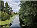
River Welland
View downstream from Albert Bridge http://www.geograph.org.uk/photo/3731007
Image: © Richard Croft
Taken: 1 Nov 2013
0.02 miles
6

The River Welland
Downstream from the Albert Bridge
Image: © Bob Harvey
Taken: 31 Jul 2022
0.03 miles
7
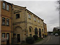
Former Goods Shed, Stamford East
Believe it or not, this building was listed for its architectural importance as a former goods shed of the Stamford and Essendine railway. It has been crassly converted into flats, surrounded by bogus waterside warehouses, and bears a brass plaque commemorating the conversion without mentioning the railway connection!
Image: © Bob Harvey
Taken: 20 Mar 2011
0.04 miles
8
![Stamford buildings [67]](https://s1.geograph.org.uk/geophotos/07/14/67/7146737_58a1a082_120x120.jpg)
Stamford buildings [67]
These two houses, Old Station House and Welland Lodge, are the main building of the former Stamford East railway station. Built in 1856 for the Stamford and Essendine private railway company. Constructed in ashlar in the Jacobean style. Listed, grade II, with details at: https://historicengland.org.uk/listing/the-list/list-entry/1222365
Stamford is a market town on the southern border of Lincolnshire, located at the lowest point that the River Welland could be forded. It is some 11 miles northwest of Peterborough and about 27 miles east of Leicester, and is set on Roman Ermine Street and the Great North Road. The picturesque town is constructed almost entirely of limestone, much of the town centre was built in the 17th and 18th centuries in Jacobean or Georgian style. Tourism is an important element of Stamford’s economy.
Image: © Michael Dibb
Taken: 28 Sep 2021
0.04 miles
9
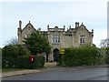
Former Stamford East Station building
Built 1856, designed by William Hurst for the Stamford and Essendine Railway, linked to the Great Northern Railway, which provided alternative facilities to the earlier Midland Railway line. The station closed in 1957 and the main building has been converted to two dwellings. Listed Grade II.
Image: © Alan Murray-Rust
Taken: 14 Feb 2020
0.04 miles
10

Former Stamford East Station building - main entrance
Built 1856, designed by William Hurst for the Stamford and Essendine Railway, linked to the Great Northern Railway, which provided alternative facilities to the earlier Midland Railway line. The station closed in 1957 and the main building has been converted to two dwellings. Listed Grade II.
This is the former main entrance leading into the booking hall.
Image: © Alan Murray-Rust
Taken: 14 Feb 2020
0.04 miles