
IMAGES TAKEN NEAR TO
Adelaide Gardens, STAMFORD, PE9 2EJ
Introduction
This page details the photographs taken nearby to Adelaide Gardens, PE9 2EJ by members of the Geograph project.
The Geograph project started in 2005 with the aim of publishing, organising and preserving representative images for every square kilometre of Great Britain, Ireland and the Isle of Man.

There are currently over 7.5m images from over14,400 individuals and you can help contribute to the project by visiting https://www.geograph.org.uk
Image Map
Images are licensed for reuse under creativecommons.org/licenses/by-sa/2.0
Notes
- Clicking on the map will re-center to the selected point.
- The higher the marker number, the further away the image location is from the centre of the postcode.
Image Listing (691 Images Found)
Images are licensed for reuse under creativecommons.org/licenses/by-sa/2.0
Image
Details
Distance
1

Adelaide Street
19th-century industrial housing marking the expansion of Stamford.
Image: © Bob Harvey
Taken: 20 Sep 2014
0.02 miles
2

No more gas
Converted to electric illumination in the 1970s, and then updated again in around 2005. The light fitting is now a low energy tube set right inside the canopy, making the lantern look empty
There was no room in the pillar for the timeclock and fuses, so they are in the small steel stump next to the lamppost.
Image: © Bob Harvey
Taken: 20 Sep 2014
0.02 miles
3
![Stamford houses [141]](https://s0.geograph.org.uk/geophotos/07/14/84/7148404_6caf2b6b_120x120.jpg)
Stamford houses [141]
Numbers 32 and 33 St Leonard's Street are a pair of early 19th century houses. Constructed of coursed rubble stone with an ashlar front under a Welsh slate roof. Listed, grade II, with details at: https://historicengland.org.uk/listing/the-list/list-entry/1062194
Stamford is a market town on the southern border of Lincolnshire, located at the lowest point that the River Welland could be forded. It is some 11 miles northwest of Peterborough and about 27 miles east of Leicester, and is set on Roman Ermine Street and the Great North Road. The picturesque town is constructed almost entirely of limestone, much of the town centre was built in the 17th and 18th centuries in Jacobean or Georgian style. Tourism is an important element of Stamford’s economy.
Image: © Michael Dibb
Taken: 2 Oct 2021
0.02 miles
4

60s Housing
At one time all of the houses on the North of Adelaide Street had separate gardens on the south (some still do: see Image)
In the 1960s some of these were built on to provide this assortment of 20th century housing.
Image: © Bob Harvey
Taken: 20 Sep 2014
0.03 miles
5
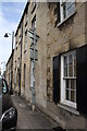
St Leonard's Street houses
There is an OS benchmark Image at the junction of the nearest two houses, right of the road sign pole
Image: © Roger Templeman
Taken: 21 May 2015
0.03 miles
6

32 & 33 St Leonard's Street, Stamford
A pair of early 19th century Georgian town houses, Listed Grade II.
Image: © Alan Murray-Rust
Taken: 14 Feb 2020
0.03 miles
7

House on the corner
This little 18th century farm cottage predates all the 19th century Industrial Era buildings in Adelaide Street, and it's frontage is aligned with the original track to the riverside meadows, not to the Victorian street. It was extended to the left some time in the early 20th century.
Image: © Bob Harvey
Taken: 20 Sep 2014
0.03 miles
8

Houses on Adelaide Street at Cherryholt Road
There is an OS benchmark Image on the near corner of the nearest house right of a downpipe
Image: © Roger Templeman
Taken: 21 May 2015
0.03 miles
9

Industrial terrace
A terrace of Victorian Industrial houses in Adelaide Street, Stamford.
Once homes for skilled workers, these are now rather middle class. The street was full of fairly expensive cars.
Image: © Bob Harvey
Taken: 20 Sep 2014
0.03 miles
10

The Croft
Apartment block built on the site of the former croft house
Image: © Bob Harvey
Taken: 20 Sep 2014
0.03 miles