
IMAGES TAKEN NEAR TO
St. Marys Hill, STAMFORD, PE9 2DW
Introduction
This page details the photographs taken nearby to St. Marys Hill, PE9 2DW by members of the Geograph project.
The Geograph project started in 2005 with the aim of publishing, organising and preserving representative images for every square kilometre of Great Britain, Ireland and the Isle of Man.

There are currently over 7.5m images from over14,400 individuals and you can help contribute to the project by visiting https://www.geograph.org.uk
Image Map
Images are licensed for reuse under creativecommons.org/licenses/by-sa/2.0
Notes
- Clicking on the map will re-center to the selected point.
- The higher the marker number, the further away the image location is from the centre of the postcode.
Image Listing (2642 Images Found)
Images are licensed for reuse under creativecommons.org/licenses/by-sa/2.0
Image
Details
Distance
1
![Stamford houses [158]](https://s1.geograph.org.uk/geophotos/07/15/02/7150241_244a4321_120x120.jpg)
Stamford houses [158]
Number 1 St Mary's Hill (to the left of the carriage entrance) and number 2 St Mary's Hill are two houses now used as offices. Built in 1794 with a number of later additions. Constructed of coursed rubble stone with ashlar dressings. Listed, grade II*, with details at: https://historicengland.org.uk/listing/the-list/list-entry/1062179
Stamford is a market town on the southern border of Lincolnshire, located at the lowest point that the River Welland could be forded. It is some 11 miles northwest of Peterborough and about 27 miles east of Leicester, and is set on Roman Ermine Street and the Great North Road. The picturesque town is constructed almost entirely of limestone, much of the town centre was built in the 17th and 18th centuries in Jacobean or Georgian style. Tourism is an important element of Stamford’s economy.
Image: © Michael Dibb
Taken: 29 Sep 2021
0.00 miles
2

River Welland at Stamford
A view of the River Welland at Stamford, Lincolnshire showing St Mary's Church in the background.
Image: © Alan Edwards
Taken: 23 Aug 2009
0.00 miles
3

View to St Mary's
View to St Mary's from the bridge over the River Welland in Stamford.
Image: © Philip Halling
Taken: 30 Jun 2013
0.01 miles
4

1 - 2 St.Mary's Hill
A pair of grade II* listed houses on St.Mary's Hill, built 1792-4 by the Earl of Exeter, reputedly to designs by Robert Lumby, latterly used as municipal offices.
Image: © Richard Croft
Taken: 1 Nov 2011
0.01 miles
5

Former Boat Inn 3 St Mary's Hill
Grade II Listed building from the later 18th century and was originally the Boat Inn, later the Boat and Railway Inn probably after 1842 and before 1868 although it was later referred to only as the Boat. Much of the fabric of the 18th century inn survives but the present appearance is the result of alterations in 1849 by Edward Browning in connection with the rebuilding of the Town Bridge and adjacent toll-house. The listing dates the fenestration and porch to 1847 despite the date stone. Remains of the following advert can be seen on the south wall 'Boat and Railway Hotel Melbourn's Sparkling Ales Bar ????? -->'. The pub closed in 1962. Directory entries include, 1828 James McCormick, 1835 William Lowson, 1842 J John Congreave, 1856-1868 John Wade, 1872 William Knipe, 1885-1889 Joseph Green Brown, 1891 Thomas Knight, 1901 John Welborn, 1905 John Hooper, 1913 John Chamberlain and 1919-1930 Richard Alonzo Hill.
Image: © Jo and Steve Turner
Taken: 23 Apr 2011
0.01 miles
6

1 & 2 St Mary's Hill, Stamford
Built as a pair of houses by the Earl of Exeter in 1792–4, later municipal offices. Listed Grade II*.
Image: © Alan Murray-Rust
Taken: 3 Mar 2020
0.01 miles
7
![Stamford buildings [83]](https://s2.geograph.org.uk/geophotos/07/15/02/7150246_4483982f_120x120.jpg)
Stamford buildings [83]
Number 3 St Mary's Hill was built in the 18th century as The Boat Inn. Much altered and given a Tudor appearance in 1849 when the bridge and toll-house were rebuilt. Constructed of coursed rubble stone with freestone dressings under a stone slate roof. Now used as offices. Listed, grade II, with details at: https://historicengland.org.uk/listing/the-list/list-entry/1062180
Stamford is a market town on the southern border of Lincolnshire, located at the lowest point that the River Welland could be forded. It is some 11 miles northwest of Peterborough and about 27 miles east of Leicester, and is set on Roman Ermine Street and the Great North Road. The picturesque town is constructed almost entirely of limestone, much of the town centre was built in the 17th and 18th centuries in Jacobean or Georgian style. Tourism is an important element of Stamford’s economy.
Image: © Michael Dibb
Taken: 29 Sep 2021
0.01 miles

9

Faded wall signage
The writing says
Boat & Railway Hotel
Melbourn's sparkling Ales.
Seen at the junction of St Martins and Wharf Road on the town side of the river bridge.
Image: © Michael Trolove
Taken: 3 Feb 2012
0.01 miles
10
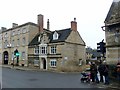
3 St Mary's Hill, Stamford
Originally a 17th century house, remodelled in 1847. Formerly the Boat Inn, with remnants of lettering painted on the gable wall. Listed Grade II. Now in use as offices.
Image: © Alan Murray-Rust
Taken: 27 Dec 2019
0.01 miles