
IMAGES TAKEN NEAR TO
St. Marys Street, STAMFORD, PE9 2DJ
Introduction
This page details the photographs taken nearby to St. Marys Street, PE9 2DJ by members of the Geograph project.
The Geograph project started in 2005 with the aim of publishing, organising and preserving representative images for every square kilometre of Great Britain, Ireland and the Isle of Man.

There are currently over 7.5m images from over14,400 individuals and you can help contribute to the project by visiting https://www.geograph.org.uk
Image Map
Images are licensed for reuse under creativecommons.org/licenses/by-sa/2.0
Notes
- Clicking on the map will re-center to the selected point.
- The higher the marker number, the further away the image location is from the centre of the postcode.
Image Listing (2366 Images Found)
Images are licensed for reuse under creativecommons.org/licenses/by-sa/2.0
Image
Details
Distance
1
![Stamford houses [166]](https://s0.geograph.org.uk/geophotos/07/15/21/7152148_704efa14_120x120.jpg)
Stamford houses [166]
Number 25 and 26 St Mary's Street face west across the head of the street. Number 25, on the left, was built circa 1766. The front is of ashlar under a stone slate mansard roof. The rear wall of coursed rubble stone has a timber-framed jettied upper storey. Number 26 consists of three ranges around the sides of a small garden. Built in the 18th century with later alterations and one range was rebuilt in the early 19th century. Constructed of ashlar under a stone slate roof. Listed, grade II*, with details at: https://historicengland.org.uk/listing/the-list/list-entry/1169809
Stamford is a market town on the southern border of Lincolnshire, located at the lowest point that the River Welland could be forded. It is some 11 miles northwest of Peterborough and about 27 miles east of Leicester, and is set on Roman Ermine Street and the Great North Road. The picturesque town is constructed almost entirely of limestone, much of the town centre was built in the 17th and 18th centuries in Jacobean or Georgian style. Tourism is an important element of Stamford’s economy.
Image: © Michael Dibb
Taken: 30 Sep 2021
0.00 miles
2
![Stamford houses [194]](https://s1.geograph.org.uk/geophotos/07/15/47/7154721_a775e0e2_120x120.jpg)
Stamford houses [194]
The Town House, number 13 Maiden Lane, was built in the mid 18th century. Constructed of ashlar under a stone slate mansard roof. Listed, grade II, with details at: https://historicengland.org.uk/listing/the-list/list-entry/1360389
Stamford is a market town on the southern border of Lincolnshire, located at the lowest point that the River Welland could be forded. It is some 11 miles northwest of Peterborough and about 27 miles east of Leicester, and is set on Roman Ermine Street and the Great North Road. The picturesque town is constructed almost entirely of limestone, much of the town centre was built in the 17th and 18th centuries in Jacobean or Georgian style. Tourism is an important element of Stamford’s economy.
Image: © Michael Dibb
Taken: 30 Sep 2021
0.00 miles
3
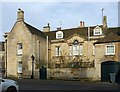
26 St Mary's Street, Stamford
The rear wing of the house, facing St George's Square, with a fine Venetian window. Built c.1765, Listed Grade II* in combination with no.25 http://www.geograph.org.uk/photo/6394252 http://www.geograph.org.uk/photo/6394256
Image: © Alan Murray-Rust
Taken: 14 Feb 2020
0.01 miles
4

Georgian oddity
Odd imposing Georgian frontage hidden away in St George's square.
Image: © Bob Harvey
Taken: 20 Sep 2014
0.01 miles
5
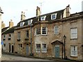
25 St Mary's Street, Stamford
The right hand house, with bay window. Built c.1765, Listed Grade II* in combination with no.26 http://www.geograph.org.uk/photo/6394252
Image: © Alan Murray-Rust
Taken: 14 Feb 2020
0.01 miles
6

13 Maiden Lane, Stamford
Built 1773 to complement no.25 St Mary's Street to the right, although there is evidence of earlier, possibly 17th century work in the building. Listed Grade II.
Image: © Alan Murray-Rust
Taken: 14 Feb 2020
0.01 miles
7
![Stamford houses [171]](https://s0.geograph.org.uk/geophotos/07/15/38/7153856_fd503ea7_120x120.jpg)
Stamford houses [171]
Number 1 St George's Square was built in the early 18th century with later alterations. Constructed of rubble stone, some brick and some timber framing with an ashlar front, under a stone slate roof. Listed, grade II, with details at: https://historicengland.org.uk/listing/the-list/list-entry/1360395
Stamford is a market town on the southern border of Lincolnshire, located at the lowest point that the River Welland could be forded. It is some 11 miles northwest of Peterborough and about 27 miles east of Leicester, and is set on Roman Ermine Street and the Great North Road. The picturesque town is constructed almost entirely of limestone, much of the town centre was built in the 17th and 18th centuries in Jacobean or Georgian style. Tourism is an important element of Stamford’s economy.
Image: © Michael Dibb
Taken: 30 Sep 2021
0.01 miles
8

Maiden Lane, Stamford
Yet another street of fine stone buildings, seen to great advantage with parking effectively prohibited throughout the central area of the town.
Image: © David Martin
Taken: 26 Jun 2022
0.01 miles

10
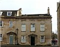
26 St Mary's Street, Stamford
Georgian town house, built c.1765, Listed Grade II* in combination with no.25 to the left http://www.geograph.org.uk/photo/6394256
Image: © Alan Murray-Rust
Taken: 14 Feb 2020
0.01 miles