
IMAGES TAKEN NEAR TO
St. Marys Street, STAMFORD, PE9 2DG
Introduction
This page details the photographs taken nearby to St. Marys Street, PE9 2DG by members of the Geograph project.
The Geograph project started in 2005 with the aim of publishing, organising and preserving representative images for every square kilometre of Great Britain, Ireland and the Isle of Man.

There are currently over 7.5m images from over14,400 individuals and you can help contribute to the project by visiting https://www.geograph.org.uk
Image Map
Images are licensed for reuse under creativecommons.org/licenses/by-sa/2.0
Notes
- Clicking on the map will re-center to the selected point.
- The higher the marker number, the further away the image location is from the centre of the postcode.
Image Listing (2456 Images Found)
Images are licensed for reuse under creativecommons.org/licenses/by-sa/2.0
Image
Details
Distance
1
![Stamford buildings [107]](https://s2.geograph.org.uk/geophotos/07/15/12/7151286_81a5044a_120x120.jpg)
Stamford buildings [107]
The Vaults public house, number 19 St Mary's Street, the left part of which is seen here with the right part at Image, was formerly the Eagle and Child Inn. The property includes buildings of many periods, from the late Middle Ages to the 19th century. The front range is largely medieval with alterations in the 18th and 19th centuries. The two rear ranges are probably 17th-century. Partly constructed of stone, partly timber framed, partly jettied to the street and underbuilt in stone and partly stuccoed. All under a stone slate roof. Listed, grade II, with details at: https://historicengland.org.uk/listing/the-list/list-entry/1062972
Stamford is a market town on the southern border of Lincolnshire, located at the lowest point that the River Welland could be forded. It is some 11 miles northwest of Peterborough and about 27 miles east of Leicester, and is set on Roman Ermine Street and the Great North Road. The picturesque town is constructed almost entirely of limestone, much of the town centre was built in the 17th and 18th centuries in Jacobean or Georgian style. Tourism is an important element of Stamford’s economy.
Image: © Michael Dibb
Taken: 30 Sep 2021
0.00 miles
2
![Stamford buildings [108]](https://s3.geograph.org.uk/geophotos/07/15/13/7151311_b03448cb_120x120.jpg)
Stamford buildings [108]
The Vaults public house, number 19 St Mary's Street, the right part of which is seen here with the left part at Image, was formerly the Eagle and Child Inn. The property includes buildings of many periods, from the late Middle Ages to the 19th century. The front range is largely medieval with alterations in the 18th and 19th centuries. The two rear ranges are probably 17th-century. Partly constructed of stone, partly timber framed, partly jettied to the street and underbuilt in stone and partly stuccoed. All under a stone slate roof. Listed, grade II, with details at: https://historicengland.org.uk/listing/the-list/list-entry/1062972
Stamford is a market town on the southern border of Lincolnshire, located at the lowest point that the River Welland could be forded. It is some 11 miles northwest of Peterborough and about 27 miles east of Leicester, and is set on Roman Ermine Street and the Great North Road. The picturesque town is constructed almost entirely of limestone, much of the town centre was built in the 17th and 18th centuries in Jacobean or Georgian style. Tourism is an important element of Stamford’s economy.
Image: © Michael Dibb
Taken: 30 Sep 2021
0.00 miles
3

St Marys Vaults
A Sam Smiths public house on St Mary's Street, Stamford.
Image: © Ian S
Taken: 5 Dec 2015
0.00 miles
4

St Marys Vaults
A Sam Smiths public house on St Mary's Street, Stamford.
Image: © Ian S
Taken: 5 Dec 2015
0.00 miles
5
![Stamford houses [162]](https://s2.geograph.org.uk/geophotos/07/15/13/7151314_36fab786_120x120.jpg)
Stamford houses [162]
Number 20 St Mary's Street incorporates in the rear wing a medieval house. The jettied street front was underbuilt and refaced in the mid 18th century and further heightened circa 1800. Constructed of coursed rubble stone, stuccoed above the ground floor, under a stone slate roof. Listed, grade II*, with details at: https://historicengland.org.uk/listing/the-list/list-entry/1062973
Stamford is a market town on the southern border of Lincolnshire, located at the lowest point that the River Welland could be forded. It is some 11 miles northwest of Peterborough and about 27 miles east of Leicester, and is set on Roman Ermine Street and the Great North Road. The picturesque town is constructed almost entirely of limestone, much of the town centre was built in the 17th and 18th centuries in Jacobean or Georgian style. Tourism is an important element of Stamford’s economy.
Image: © Michael Dibb
Taken: 30 Sep 2021
0.00 miles
6

St Marys Vaults
One of two Sam Smith's public houses in Stamford.
Image: © Ian S
Taken: 19 Aug 2012
0.01 miles
7
![Stamford buildings [109]](https://s0.geograph.org.uk/geophotos/07/15/13/7151320_13380682_120x120.jpg)
Stamford buildings [109]
Number 21 St Mary's Street was built, in the Gothic style, as an office by the owner of number 22 St Mary's Street circa 1827. Constructed of small, coursed rubble stone with ashlar dressings under a stone slate roof. Listed, grade II, with details at: https://historicengland.org.uk/listing/the-list/list-entry/1360029
Stamford is a market town on the southern border of Lincolnshire, located at the lowest point that the River Welland could be forded. It is some 11 miles northwest of Peterborough and about 27 miles east of Leicester, and is set on Roman Ermine Street and the Great North Road. The picturesque town is constructed almost entirely of limestone, much of the town centre was built in the 17th and 18th centuries in Jacobean or Georgian style. Tourism is an important element of Stamford’s economy.
Image: © Michael Dibb
Taken: 30 Sep 2021
0.01 miles
8

St Mary's Street, Stamford
An eclectic mix of buildings, starting with the public house, St Mary's Vaults.
Image: © Dave Hitchborne
Taken: 13 Jul 2013
0.01 miles
9

Touched by sudden sunshine
It had been pouring with rain while I shopped, but briefly the clouds blew away and the dying sun danced across the rooftops.
The building on the left is the pub known as St Mary's Vaults, and the white one can be dated as far back as the 13th Century, though it has a Georgian facade.
see https://www.historicengland.org.uk/listing/the-list/list-entry/1169751 and https://www.historicengland.org.uk/listing/the-list/list-entry/1062973 for details
Image: © Bob Harvey
Taken: 21 Dec 2015
0.01 miles
10
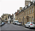
Stamford: St Mary's Street
A grey November afternoon. In the distance on the left is the stately colonnaded facade of the former Stamford Hotel (1810-29), "one of the grandest of Regency hotels" according to Nikolaus Pevsner. The Shell Guide explains that it was built to be the town's Whig Centre, a counterpart to the Tory George Hotel.
Image: © John Sutton
Taken: 1 Nov 2016
0.01 miles