
IMAGES TAKEN NEAR TO
Wellington Lane, STAMFORD, PE9 1QB
Introduction
This page details the photographs taken nearby to Wellington Lane, PE9 1QB by members of the Geograph project.
The Geograph project started in 2005 with the aim of publishing, organising and preserving representative images for every square kilometre of Great Britain, Ireland and the Isle of Man.

There are currently over 7.5m images from over14,400 individuals and you can help contribute to the project by visiting https://www.geograph.org.uk
Image Map
Images are licensed for reuse under creativecommons.org/licenses/by-sa/2.0
Notes
- Clicking on the map will re-center to the selected point.
- The higher the marker number, the further away the image location is from the centre of the postcode.
Image Listing (2322 Images Found)
Images are licensed for reuse under creativecommons.org/licenses/by-sa/2.0
Image
Details
Distance
1

Broad Street/Red Lion Street
Looking down Wellington Lane, at the bottom of which is High Street and the shops.
Image: © Dave Hitchborne
Taken: 13 Jul 2013
0.01 miles
2

8 High Street, Stamford
Originally a separate house facing towards Broad Street, but now incorporated into the High Street premises. Mid 18th century. There is some fine decorative plaster work under the eaves http://www.geograph.org.uk/photo/6407682 , Listed Grade II.
Image: © Alan Murray-Rust
Taken: 3 Mar 2020
0.01 miles
3
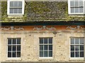
8 High Street, Stamford ? detail
Decorative plasterwork with demon heads on the rear of the building facing Broad Street. Listed Grade II. See http://www.geograph.org.uk/photo/6407680 for location.
Image: © Alan Murray-Rust
Taken: 3 Mar 2020
0.01 miles
4

Corn Exchange
The grand Corn Exchange on Broad Street by Rev. Henry De Foe Baker in 1839, lately a theatre, but currently disused
Image: © Richard Croft
Taken: 29 Jul 2007
0.01 miles
5
![Stamford buildings [40]](https://s3.geograph.org.uk/geophotos/07/13/92/7139231_f7c0efab_120x120.jpg)
Stamford buildings [40]
Number 5 Red Lion Street was built in the early 19th century as a warehouse. Constructed brick with a front of coursed rubble stone and freestone dressings, all under a stone slate roof. Listed, for group value, grade II, with details at: https://historicengland.org.uk/listing/the-list/list-entry/1062215
Stamford is a market town on the southern border of Lincolnshire, located at the lowest point that the River Welland could be forded. It is some 11 miles northwest of Peterborough and about 27 miles east of Leicester, and is set on Roman Ermine Street and the Great North Road. The picturesque town is constructed almost entirely of limestone, much of the town centre was built in the 17th and 18th centuries in Jacobean or Georgian style. Tourism is an important element of Stamford’s economy.
Image: © Michael Dibb
Taken: 29 Sep 2021
0.01 miles
6
![Stamford buildings [191]](https://s0.geograph.org.uk/geophotos/07/15/91/7159108_42cea5e3_120x120.jpg)
Stamford buildings [191]
Numbers 50 and 51 Broad Street were built circa 1830. Constructed of coursed rubble stone, the front partly rendered, all under a hipped stone slate mansard roof. Listed, grade II, with details at: https://historicengland.org.uk/listing/the-list/list-entry/1147695
Stamford is a market town on the southern border of Lincolnshire, located at the lowest point that the River Welland could be forded. It is some 11 miles northwest of Peterborough and about 27 miles east of Leicester, and is set on Roman Ermine Street and the Great North Road. The picturesque town is constructed almost entirely of limestone, much of the town centre was built in the 17th and 18th centuries in Jacobean or Georgian style. Tourism is an important element of Stamford’s economy.
Image: © Michael Dibb
Taken: 29 Sep 2021
0.01 miles
7
![Stamford buildings [131]](https://s3.geograph.org.uk/geophotos/07/15/47/7154727_e4f3ee91_120x120.jpg)
Stamford buildings [131]
Number 7 High Street was originally part of the same building as number 6 High Street. The seven bay main range was remodelled or rebuilt in the mid 18th century with an ashlar front. Number 7 has an early 19th century shopfront with a central doorway, flanking bow windows and entrances to side passages. The right passage served the house at the rear of the shop, and the left passage is a public footpath known as Wellington Lane. Listed, grade II*, with details at: https://historicengland.org.uk/listing/the-list/list-entry/1147799
Stamford is a market town on the southern border of Lincolnshire, located at the lowest point that the River Welland could be forded. It is some 11 miles northwest of Peterborough and about 27 miles east of Leicester, and is set on Roman Ermine Street and the Great North Road. The picturesque town is constructed almost entirely of limestone, much of the town centre was built in the 17th and 18th centuries in Jacobean or Georgian style. Tourism is an important element of Stamford’s economy.
Image: © Michael Dibb
Taken: 30 Sep 2021
0.01 miles
8

Rear of 8 High Street
Rear portion of an 19th century property in the high street. This is a grade II listed building, see https://historicengland.org.uk/listing/the-list/list-entry/1062225
I notice the moulded swags in the pediment.
Image: © Bob Harvey
Taken: 12 Nov 2014
0.01 miles
9

The Best Bakers
I think this is the best baker's shop in Stamford. That might seem a very subjective thing to say, but that is what I think. Try the Lardy cake.
This may also be the southernmost place in the UK to call a Crumpet a Pykelet.
Image: © Bob Harvey
Taken: 12 Nov 2014
0.01 miles
10
![Stamford buildings [132]](https://s0.geograph.org.uk/geophotos/07/15/47/7154728_429d7296_120x120.jpg)
Stamford buildings [132]
Number 8 High Street is two parallel ranges and a central linking block. The rear range was built in the early 18th century and the front range was built in the 1760s. The front range is constructed of red brick under a stone slate mansard roof. The rear range is of coursed rubble stone. The building was formerly the Globe Inn. Listed, grade II, with details at: https://historicengland.org.uk/listing/the-list/list-entry/1062225
Stamford is a market town on the southern border of Lincolnshire, located at the lowest point that the River Welland could be forded. It is some 11 miles northwest of Peterborough and about 27 miles east of Leicester, and is set on Roman Ermine Street and the Great North Road. The picturesque town is constructed almost entirely of limestone, much of the town centre was built in the 17th and 18th centuries in Jacobean or Georgian style. Tourism is an important element of Stamford’s economy.
Image: © Michael Dibb
Taken: 30 Sep 2021
0.01 miles