
IMAGES TAKEN NEAR TO
New Cross Road, STAMFORD, PE9 1AH
Introduction
This page details the photographs taken nearby to New Cross Road, PE9 1AH by members of the Geograph project.
The Geograph project started in 2005 with the aim of publishing, organising and preserving representative images for every square kilometre of Great Britain, Ireland and the Isle of Man.

There are currently over 7.5m images from over14,400 individuals and you can help contribute to the project by visiting https://www.geograph.org.uk
Image Map
Images are licensed for reuse under creativecommons.org/licenses/by-sa/2.0
Notes
- Clicking on the map will re-center to the selected point.
- The higher the marker number, the further away the image location is from the centre of the postcode.
Image Listing (510 Images Found)
Images are licensed for reuse under creativecommons.org/licenses/by-sa/2.0
Image
Details
Distance
1

Bandstand in the Recreation Ground
The decorators are in.
Image: © Michael Trolove
Taken: 2 Mar 2012
0.05 miles
2

Estate houses north of the recreation ground, Stamford
The old Stamford borough built an estate of large, well-appointed, houses to rent. They remain popular, although parking spaces were never thought of.
Image: © Bob Harvey
Taken: 12 Mar 2011
0.06 miles
3

Recreation ground
A new skatepark has been added to the recreation ground, with some rather clever fencing to avoid the anticipated noise. It looks rather good.
Image: © Bob Harvey
Taken: 6 Dec 2014
0.10 miles
4

The bandstand in Belton Gardens north of the recreation ground
The Recreation Ground, Stamford, dates back to a parliamentary act of March 1871, a Bill passed to enclose Stamford’s open fields, which included the creation of The Recreation Ground, some 8 acres in size.
In 1876 the Stamford Mercury said that ‘the site is at the back of North Street, a locality which will render the Recreation Ground useless to the respectable portion of the community and leaves its enjoyment exclusively to those who are not particular about their associations’. The present park-like layout dates to 1909.
Image: © Steve Fareham
Taken: 27 Apr 2009
0.11 miles
5

Public conveniences, Stamford Recreation Ground
Built in 2012, with donations from local businesses and organisations as part of a 'Spend-A-Penny' campaign.
Image: © Tim Heaton
Taken: 25 Jan 2019
0.11 miles
6

Skate Park
The skate park seen in Image
See http://www.stamfordmercury.co.uk/news/community/community-news/video-stamford-skatepark-opens-for-the-first-time-1-5766666 and http://www.stamfordmercury.co.uk/news/community/community-news/stamford-skatepark-is-a-clear-success-1-6146419
Image: © Bob Harvey
Taken: 6 Dec 2014
0.11 miles
7
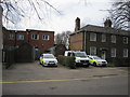
Stamford police station, Entrance to compound
To the south of Image is the entrance to the compound, largely filled with the 1960s flat-roofed extension behind the main building
Image: © Bob Harvey
Taken: 12 Mar 2011
0.11 miles
8

Estate houses by the recreation ground, Stamford
Junction of Cliff Road and Cliff Crescent. A mixture of 19th century and earlier rooflines, and the 15th century spire of All Saints framed between two mid-20th century council houses. Typical Stamford really.
Image: © Bob Harvey
Taken: 12 Mar 2011
0.11 miles
9

Stamford police station, South elevation, current station entrance
This is the main front elevation of Stamford police station, built in the 1930s to the west of the original Victorian station glimpsed on the right. This frontage looks onto North Street.
In recent years the trees that were once seen to the left have been removed, and a new car park opened up reached by a gravel track from the front yard seen here.
Image: © Bob Harvey
Taken: 12 Mar 2011
0.12 miles
10
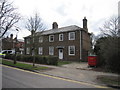
Stamford police station, Former police houses
One of two identical blocks of former Police houses in Cliff Road. The other block is in use as private homes, this one is unused and approaching dereliction.
Image: © Bob Harvey
Taken: 12 Mar 2011
0.12 miles