
IMAGES TAKEN NEAR TO
Oundle Road, PETERBOROUGH, PE8 5BZ
Introduction
This page details the photographs taken nearby to Oundle Road, PE8 5BZ by members of the Geograph project.
The Geograph project started in 2005 with the aim of publishing, organising and preserving representative images for every square kilometre of Great Britain, Ireland and the Isle of Man.

There are currently over 7.5m images from over14,400 individuals and you can help contribute to the project by visiting https://www.geograph.org.uk
Image Map
Images are licensed for reuse under creativecommons.org/licenses/by-sa/2.0
Notes
- Clicking on the map will re-center to the selected point.
- The higher the marker number, the further away the image location is from the centre of the postcode.
Image Listing (46 Images Found)
Images are licensed for reuse under creativecommons.org/licenses/by-sa/2.0
Image
Details
Distance


3
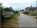
Stoke Doyle - twinned with Barcelona
As I cycled in to Stoke Doyle, I had to turn around and check I'd seen what I thought I had !
Stoke Doyle (population about 70) twinned with Barcelona (population about 4 million) ... in reality an unofficial and humorous spoof http://news.bbc.co.uk/local/northampton/hi/people_and_places/newsid_9038000/9038240.stm and Wikipedia has succumbed to the joke http://en.wikipedia.org/wiki/Stoke_Doyle
But what else does Stoke Doyle have that Barcelona does not?
Martin Stansfield, who put up the sign, thought long and hard before saying: "Sheep."
Image: © Richard Croft
Taken: 5 Aug 2014
0.04 miles
4

The Row
Stoke Doyle never really recovered from the Plague in 1665 and the decreased population of a nucleated village http://www.geograph.org.uk/photo/4107412 re-settled as a linear village along Main Street, characterised by this row of 14 mid-19th century cottages known as The Row.
Image: © Richard Croft
Taken: 5 Aug 2014
0.10 miles

6

The Bridge, Stream & Church at Stoke Doyle
The bridge with parapet in the foreground is late 18th century and Grade II listed. The stream makes its way a mile across the fields to the River Nene past the church of St Rumbald built 1722-25.
Image: © Nigel Stickells
Taken: 21 Jan 2007
0.13 miles
7

Stoke Doyle
View from Church Road towards the Shuckburgh Arms http://www.geograph.org.uk/photo/4107405 at Stoke Doyle
Image: © Richard Croft
Taken: 5 Aug 2014
0.13 miles
8

Shuckburgh Arms pub, Stoke Doyle
The pub was built in the mid C18. See http://www.britishlistedbuildings.co.uk/en-232846-shuckburgh-arms-public-house-stoke-doyle#.VXdM9PlViko for entry in British Listed Buildings.
Image: © Bikeboy
Taken: 30 May 2015
0.13 miles
9

The Shuckburgh Arms
Grade II listed, mid-18th century acclaimed village pub, restaurant and B&B http://www.shuckburgh-arms.co.uk/
Image: © Richard Croft
Taken: 5 Aug 2014
0.13 miles
10

Stoke Doyle Road
Looking towards Church Lane. You can just see St Rumbald's Church.
Image: © David Howard
Taken: 11 Jul 2020
0.14 miles