
IMAGES TAKEN NEAR TO
Springfield Road, PETERBOROUGH, PE7 3JT
Introduction
This page details the photographs taken nearby to Springfield Road, PE7 3JT by members of the Geograph project.
The Geograph project started in 2005 with the aim of publishing, organising and preserving representative images for every square kilometre of Great Britain, Ireland and the Isle of Man.

There are currently over 7.5m images from over14,400 individuals and you can help contribute to the project by visiting https://www.geograph.org.uk
Image Map
Images are licensed for reuse under creativecommons.org/licenses/by-sa/2.0
Notes
- Clicking on the map will re-center to the selected point.
- The higher the marker number, the further away the image location is from the centre of the postcode.
Image Listing (19 Images Found)
Images are licensed for reuse under creativecommons.org/licenses/by-sa/2.0
Image
Details
Distance
1

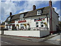
The Duck and Drake, Main Street, Yaxley
Image: © Richard Humphrey
Taken: 28 Mar 2013
0.09 miles
3

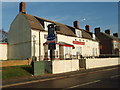
High Street, Yaxley, Cambs.
This late C17th building is said to have been home to a Dutchmen who came to assist in draining the fens. The main bar of the Duck and Drake public house is situated in the original house, with extensions having been added to the property over the years. Queen Elizabeth I was interested in draining the fens to provide for agriculture, but it was the Duke of Bedford who, in 1626, gathered support from a group of investors and called in Dutch engineer Cornelius Varmuyden to drain Hatfield Chase. The scheme was violently opposed by the natives of the fens, both because Vermuyden employed Dutch workers, and because of the changes that draining would have on their traditional hunting and fishing rights. They attacked the foreign workers, and it was only after an agreement was reached to compensate the fen-dwellers and employ English workers that the project could proceed. Next Vermuyden worked out a scheme to drain the Great Fen, in return for which he was promised 96,000 acres for himself. His work was undone in 1642 when the Parliamentary army broke his dykes in an effort to flood land and stop a Royalist army advance. In 1649 Vermuyden went back to work, this time with the labour provided by Scottish and Dutch prisoners of war. The Great Fen reclamation drained over 40,000 acres of land, but had the unexpected consequence of causing the neighbouring farmland to sink. This happened when the peat topsoil dried out and settled. In some cases land sunk up to 20 feet.
Image: © David Hallam-Jones
Taken: 19 Aug 2019
0.10 miles
5
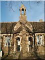
Two Door Entrance to the Amenity Hall Yaxley
Home of Yaxley parish council and others. Image
Image: © Michael Trolove
Taken: 31 Jan 2009
0.12 miles
6

Yaxley Amenity Hall
This once school hall is now the hub for the parish council and village community groups.
Image: © Michael Trolove
Taken: 31 Jan 2009
0.14 miles
7
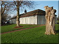
Sports Changing Facility Yaxley
The Middleton road sports ground is a large well kept sports ground providing sport and recreation for Yaxley residents and visiting teams. As you can see the high security fence is the only way to stop the mindless few from destroying an otherwise attractive and well used facility.
Image: © Michael Trolove
Taken: 31 Jan 2009
0.14 miles
8
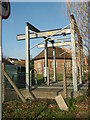
Water Pumping Facility Yaxley
On the corner of Windsor road and Main street.
Image: © Michael Trolove
Taken: 31 Jan 2009
0.15 miles
9

Skate Boarders Delight Yaxley
A modern day addition to the recreation field on Middleton road.
Image: © Michael Trolove
Taken: 31 Jan 2009
0.15 miles
10
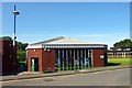
Yaxley Library
Small community library near the shopping centre in Lansdowne Road. http://www.cambridgeshire.gov.uk/leisure/libraries/directory/yaxley_library.htm
Image: © Tiger
Taken: 15 Aug 2008
0.17 miles