IMAGES TAKEN NEAR TO
Foxgloves, PETERBOROUGH, PE6 8SH
Introduction
This page details the photographs taken nearby to Foxgloves, PE6 8SH by members of the Geograph project.
The Geograph project started in 2005 with the aim of publishing, organising and preserving representative images for every square kilometre of Great Britain, Ireland and the Isle of Man.

There are currently over 7.5m images from over14,400 individuals and you can help contribute to the project by visiting https://www.geograph.org.uk
Image Map
Images are licensed for reuse under creativecommons.org/licenses/by-sa/2.0
Notes
- Clicking on the map will re-center to the selected point.
- The higher the marker number, the further away the image location is from the centre of the postcode.
Image Listing (6 Images Found)
Images are licensed for reuse under creativecommons.org/licenses/by-sa/2.0
Image
Details
Distance
1
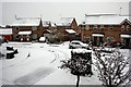
Bryony Way, Deeping St. James
View of Bryony Way, Deeping St. James under a thin covering of snow
Image: © Adam Brookes
Taken: 23 Mar 2008
0.13 miles
2
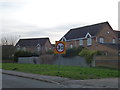
Speed limit on Linchfield Road
The speed limit drops to 30 mph as the road enters the north of Market Deeping
Image: © Richard Humphrey
Taken: 3 Feb 2014
0.19 miles
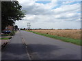
3
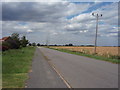
Linchfield Road
Looking towards Swines Meadow Farm Garden Centre.
Image: © Ajay Tegala
Taken: 15 Jul 2008
0.19 miles
4
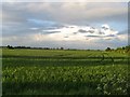
A Market Deeping Field
Typical of the large open fields of the fens. Unfortunately I'm no crop expert.
Image: © James
Taken: 22 May 2005
0.20 miles
5
Linchfield Road
Photograph taken close to the junction with Crowson Way. Fen Field Mews housing estate is just visible on the left.
Image: © Ajay Tegala
Taken: 15 Jul 2008
0.21 miles
6
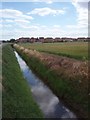
Ditch beside Linchfield Road
A steep-sided ditch parallel to Linchfield Road (visible to the left, in this photograph). The Campion Drive housing estate is visible on the horizon (built c. 1990).
Image: © Ajay Tegala
Taken: 15 Jul 2008
0.21 miles