
IMAGES TAKEN NEAR TO
Allen Close, PETERBOROUGH, PE6 8EZ
Introduction
This page details the photographs taken nearby to Allen Close, PE6 8EZ by members of the Geograph project.
The Geograph project started in 2005 with the aim of publishing, organising and preserving representative images for every square kilometre of Great Britain, Ireland and the Isle of Man.

There are currently over 7.5m images from over14,400 individuals and you can help contribute to the project by visiting https://www.geograph.org.uk
Image Map
Images are licensed for reuse under creativecommons.org/licenses/by-sa/2.0
Notes
- Clicking on the map will re-center to the selected point.
- The higher the marker number, the further away the image location is from the centre of the postcode.
Image Listing (7 Images Found)
Images are licensed for reuse under creativecommons.org/licenses/by-sa/2.0
Image
Details
Distance
1
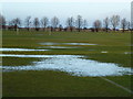
Flooded playing field, Litchfield Road, Market Deeping
Image: © Richard Humphrey
Taken: 26 Jan 2014
0.17 miles
2
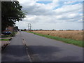
Linchfield Road
Photograph taken close to the junction with Crowson Way. Fen Field Mews housing estate is just visible on the left.
Image: © Ajay Tegala
Taken: 15 Jul 2008
0.17 miles
3

The Walnut Tree (1), 32 Horsegate, Deeping St. James
A popular local pub that sometimes has live music. The official address seems to be Deeping St. James, but maps show it as in or near Deeping Gate.
Image
Image: © P L Chadwick
Taken: 28 Apr 2012
0.18 miles
4

The Walnut Tree (2) - sign, 32 Horsegate, Deeping St. James
The sign makes clear that the pub considers itself to be in Deeping St.James, which is in Lincolnshire, and not in the adjacent Deeping Gate, which is now within the boundaries of the City of Peterborough. Also on the front of the building are two traditional lamps with the pub's name.
Public houses and inns with this name often have a sign showing someone or something underneath the walnut tree. This one has a squirrel.
Image
Image: © P L Chadwick
Taken: 28 Apr 2012
0.18 miles
5

The Walnut Tree, Deeping St. James
This popular local pub, which is located on Horsegate, was built in the 1840s.
Source: https://issuu.com/zerosixdesign/docs/deeping_mag/s/23280361
Image: © Paul Bryan
Taken: 25 Sep 2025
0.18 miles
6
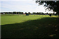
The Deepings playing field
This large playing field is on the edge of Market Deeping on the corner of Linchfield Road and Horsegate (B1525).
Image: © Kate Jewell
Taken: 18 Oct 2007
0.19 miles
