
IMAGES TAKEN NEAR TO
Park Drive, PETERBOROUGH, PE6 8BG
Introduction
This page details the photographs taken nearby to Park Drive, PE6 8BG by members of the Geograph project.
The Geograph project started in 2005 with the aim of publishing, organising and preserving representative images for every square kilometre of Great Britain, Ireland and the Isle of Man.

There are currently over 7.5m images from over14,400 individuals and you can help contribute to the project by visiting https://www.geograph.org.uk
Image Map
Images are licensed for reuse under creativecommons.org/licenses/by-sa/2.0
Notes
- Clicking on the map will re-center to the selected point.
- The higher the marker number, the further away the image location is from the centre of the postcode.
Image Listing (109 Images Found)
Images are licensed for reuse under creativecommons.org/licenses/by-sa/2.0
Image
Details
Distance
1

The Green School
Small former school building opposite St. Guthlac's church.
Image: © Ajay Tegala
Taken: 23 Aug 2008
0.05 miles
2

Old Milepost
Old milepost on what was the A.15 at Market Deeping, Lincolnshire. For close up view see http://www.geograph.org.uk/photo/1461348
Image: © Keith Evans
Taken: 27 Aug 2009
0.06 miles
3

Church Street, Market Deeping
Village Hall - The poster on the railings was announcing that the hall can be booked for meetings or parties. The building stands opposite the Parish church. It was built as the Green School in 1851, from funds bequeathed by Mrs Mary Wensor, daughter of George and Sarah Allison. It was endowed by Mrs Elizabeth Molecey, for 100 girls and infants.
Image: © Dave Hitchborne
Taken: 26 Aug 2013
0.07 miles
4
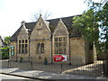
The Green School Hall, Market Deeping
The Green School, which is situated on Church Street directly opposite St.Guthlac's Church, was built on land donated in 1851 by the then Rector, the Reverend William Hildyard. It continued to serve as an infant school until the present Church of England Primary School was opened on Godsey Lane in 1967. The building now functions as a church hall.
Source: http://lincoln.ourchurchweb.org.uk/marketdeeping/our-church-hal1/page1/
Image: © Paul Bryan
Taken: 27 May 2016
0.07 miles
5

Greens School, Market Deeping
Dates from 1851 https://historicengland.org.uk/listing/the-list/list-entry/1165270
Image: © Jonathan Thacker
Taken: 1 Sep 2021
0.07 miles
6

Houses on Church Street in Market Deeping
There is a date stone over the door dated 1697
Image: © Richard Humphrey
Taken: 6 Aug 2016
0.07 miles
7

St Guthlac, Market Deeping: church path
Image: © Basher Eyre
Taken: 25 Jun 2016
0.07 miles

9
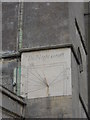
Sundial on St. Guthlac's Church, Market Deeping
The church was largely built in the 15th. century although it incorporates parts of an earlier church dating from the 12th. century. It underwent extensive renovation in the 19th. century. The church is dedicated to St. Guthlac of Crowland (617-714).
Image: © Paul Bryan
Taken: 2 May 2015
0.08 miles
10

The Church of St Guthlac, Market Deeping
This church was thirty first on the list to be photographed on this day - http://www.geograph.org.uk/photo/3624846 Perpendicular with earlier nave arcades. Restored in 1875. The church has more peaceful surroundings since the town was by-passed.
Image: © Dave Hitchborne
Taken: 26 Aug 2013
0.08 miles