IMAGES TAKEN NEAR TO
Crowland Road, PETERBOROUGH, PE6 0PB
Introduction
This page details the photographs taken nearby to Crowland Road, PE6 0PB by members of the Geograph project.
The Geograph project started in 2005 with the aim of publishing, organising and preserving representative images for every square kilometre of Great Britain, Ireland and the Isle of Man.

There are currently over 7.5m images from over14,400 individuals and you can help contribute to the project by visiting https://www.geograph.org.uk
Image Map
Images are licensed for reuse under creativecommons.org/licenses/by-sa/2.0
Notes
- Clicking on the map will re-center to the selected point.
- The higher the marker number, the further away the image location is from the centre of the postcode.
Image Listing (5 Images Found)
Images are licensed for reuse under creativecommons.org/licenses/by-sa/2.0
Image
Details
Distance
1
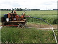
Irrigation pump, Little Tower's Fen
A six cylinder Ford engine lifting water from the roadside drain and pumping it to the distant irrigation gun.
Image: © Michael Trolove
Taken: 18 Jun 2009
0.06 miles
3
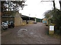
Singlecote Farm
Entrance from the B1040
Image: © Morris Doris
Taken: 15 Dec 2010
0.13 miles
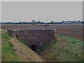
5
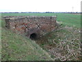
Old brick bridge near Singlecote Farm
On Crowland Road north west of Thorney crossing over Singlesole Drain
Image: © Richard Humphrey
Taken: 5 Mar 2012
0.14 miles