
IMAGES TAKEN NEAR TO
Westfield Road, PETERBOROUGH, PE3 9TJ
Introduction
This page details the photographs taken nearby to Westfield Road, PE3 9TJ by members of the Geograph project.
The Geograph project started in 2005 with the aim of publishing, organising and preserving representative images for every square kilometre of Great Britain, Ireland and the Isle of Man.

There are currently over 7.5m images from over14,400 individuals and you can help contribute to the project by visiting https://www.geograph.org.uk
Image Map
Images are licensed for reuse under creativecommons.org/licenses/by-sa/2.0
Notes
- Clicking on the map will re-center to the selected point.
- The higher the marker number, the further away the image location is from the centre of the postcode.
Image Listing (36 Images Found)
Images are licensed for reuse under creativecommons.org/licenses/by-sa/2.0
Image
Details
Distance
1
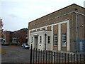
Baker Perkins Apprentice School in Peterborough
This is all that remains of the massive Baker Perkins factory that once employed hundreds of people on Westfield Road. The former factory site is now a park and a prison and the manufacturing base has been relocated to a purpose built factory on the outskirts of Peterborough.
Image: © Richard Humphrey
Taken: 2 Nov 2010
0.02 miles
2
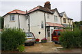
Nos. 74 and 76 Grange Road
There is an Ordnance Survey cut mark benchmark www.bench-marks.org.uk/bm88361 behind the flower box to the right of the grey car
Image: © phil Richards
Taken: 22 Oct 2017
0.04 miles
3

Saville Road Motors Ltd offices
There is an Ordnance Survey benchmark Image on the near corner, left hand face, of the building and an OS active triangulation station Image mounted at the gable apex
Image: © Roger Templeman
Taken: 10 Sep 2017
0.07 miles
4

Benchmark on Saville Road Motors Ltd building
Ordnance Survey cut mark benchmark described on the Bench Mark Database at www.bench-marks.org.uk/bm88359
Image: © Roger Templeman
Taken: 10 Sep 2017
0.07 miles
5

Ordnance Survey Leica active triangulation station, Saville Road
More information about the station may be found at http://trigpointing.uk/trig/7757
'Active stations are GPS receivers which constantly write Receiver Independent Exchange Format (RINEX) data out to the Ordnance Survey OS Net website. The files are publically downloadable, and allow measurements taken in the field to be post-processed for greater accuracy.
The Active Station network came online in early 2000. Most early stations were placed in pairs and had TRIMBLE 4000SSI receivers with conical antennae in small arrays, though freestanding Leica CRS1000 and Ashtech UZ-12 receivers were also used.
A major upgrade to the active network was started in December 2008 when most active stations were equipped with GNSS-enabled receivers with single dome-shaped antennae such as the Leica GRX1200 or AR25'.
Image: © Roger Templeman
Taken: 10 Sep 2017
0.07 miles
6
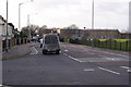
Road junction by Westwood Bridge
Site of the old Baker Perkins factory on the right hand side
Image: © Chris Stafford
Taken: 18 Jan 2007
0.09 miles
7

Benchmark on No. 56 Grange Road
Ordnance Survey cut mark benchmark described on the Bench Mark Database at www.bench-marks.org.uk/bm88362
Image: © phil Richards
Taken: 22 Oct 2017
0.10 miles

9

Nos. 54 and 56 Grange Road
There is an Ordnance Survey benchmark Image on the side of the nearer house at its front corner
Image: © phil Richards
Taken: 22 Oct 2017
0.11 miles
