IMAGES TAKEN NEAR TO
Axiom Avenue, PETERBOROUGH, PE3 7EJ
Introduction
This page details the photographs taken nearby to Axiom Avenue, PE3 7EJ by members of the Geograph project.
The Geograph project started in 2005 with the aim of publishing, organising and preserving representative images for every square kilometre of Great Britain, Ireland and the Isle of Man.

There are currently over 7.5m images from over14,400 individuals and you can help contribute to the project by visiting https://www.geograph.org.uk
Image Map
Images are licensed for reuse under creativecommons.org/licenses/by-sa/2.0
Notes
- Clicking on the map will re-center to the selected point.
- The higher the marker number, the further away the image location is from the centre of the postcode.
Image Listing (20 Images Found)
Images are licensed for reuse under creativecommons.org/licenses/by-sa/2.0
Image
Details
Distance
1
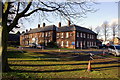
PPDC Training Centre, Cottesmore Close, Peterborough
This building was originally The Officers’ Mess, Royal Air Force, Peterborough. Where No 7 Flying Training School, Royal Air Force, was formed on 2nd December 1935 to train pilots of many Allied Nationalities during World War II. After the war, Westwood Airfield continued in Civil use as a base for a Royal Mail delivery service for East Anglia, using early helicopters. It is currently a Council training centre.
Image: © Julian Dowse
Taken: 27 Jan 2007
0.06 miles
3
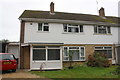
No.12 Cottesmore Close
There is an Ordnance Survey benchmark Image on the front face of the brick column at the left hand corner of the house
Image: © phil Richards
Taken: 22 Oct 2017
0.10 miles
4
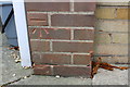
Benchmark on No. 12 Cottesmore Close
Ordnance Survey cut mark benchmark described on the Bench Mark Database at www.bench-marks.org.uk/bm88356
Image: © phil Richards
Taken: 22 Oct 2017
0.10 miles
5
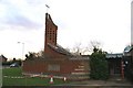
St Judes C of E church Westwood
Modern Church with striking tower design
Image: © Chris Stafford
Taken: 18 Jan 2007
0.12 miles
6
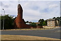
Church of St Jude, Westwood, Peterborough
Building started in 1968 on land donated by the Fitzwilliam Trust (Cf. Fitzwilliam family of Bretton Park), to serve the new housing estates being developed on the west side of Peterborough http://www.stjudepeterborough.org.uk/about-us/our-history/
Image: © Tim Heaton
Taken: 9 Aug 2022
0.12 miles
7
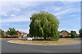
Roundabout 47, available for sponsorship
Poor, unloved thing. Nice tree though.
Image: © Tim Heaton
Taken: 9 Aug 2022
0.12 miles
8
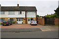
Houses on west side of Wilton Drive
Ordnance Survey documents indicate that a benchmark levelled at 17.852m above Newlyn Datum was cut on the garage behind #2 Wilton Drive in 1965. However, it appears the garage has been demolished and the houses rebuilt. See www.bench-marks.org.uk/bm88358
Image: © phil Richards
Taken: 22 Oct 2017
0.14 miles