
IMAGES TAKEN NEAR TO
Chantry Lane, SWAFFHAM, PE37 8HU
Introduction
This page details the photographs taken nearby to Chantry Lane, PE37 8HU by members of the Geograph project.
The Geograph project started in 2005 with the aim of publishing, organising and preserving representative images for every square kilometre of Great Britain, Ireland and the Isle of Man.

There are currently over 7.5m images from over14,400 individuals and you can help contribute to the project by visiting https://www.geograph.org.uk
Image Map
Images are licensed for reuse under creativecommons.org/licenses/by-sa/2.0
Notes
- Clicking on the map will re-center to the selected point.
- The higher the marker number, the further away the image location is from the centre of the postcode.
Image Listing (26 Images Found)
Images are licensed for reuse under creativecommons.org/licenses/by-sa/2.0
Image
Details
Distance
1

Larwood Close, Necton
Where it meets Chantry Lane (on left), School Road (ahead), and Ketts Hill.
Image: © Phillip Perry
Taken: 20 Mar 2010
0.04 miles

3

Necton: cottages in Chantry Lane
Looking north, heading out of the village, at some of the more original cottages having passed some modern development just behind us. To the left is Image
Image: © Chris Downer
Taken: 29 Nov 2010
0.10 miles
4
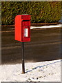
Necton: postbox № PE37 510, Chantry Lane
This small postbox is mounted on a slightly wonky metal pole on the corner of Brackenwoods. We can identify it as dating from 1994or later because it is inscribed with the words ROYAL MAIL rather than POST OFFICE along the top.
Image: © Chris Downer
Taken: 29 Nov 2010
0.11 miles
5

Necton: Brackenwoods
A small development of bungalows off Chantry Lane, to the northeast of the village centre.
Image: © Chris Downer
Taken: 29 Nov 2010
0.13 miles
6

St. Andrew's Lane, Necton
About 30 or so houses in a clump surrounded by open countryside.
Image: © Phillip Perry
Taken: 11 Mar 2009
0.16 miles
7

Necton: Slightly spooky display at 22, St. Andrews Lane
Image: © Michael Garlick
Taken: 30 Oct 2022
0.18 miles
8

Necton: 'Cambridge House', 24, St. Andrews Lane
Image: © Michael Garlick
Taken: 30 Oct 2022
0.18 miles
9

Necton: Chantry Lane
Looking south, towards the village centre, after much snowfall.
Image: © Chris Downer
Taken: 29 Nov 2010
0.18 miles
10

Necton: footprints in the snow in Chantry Lane
Looking north during the cold snap of November/December 2010 which featured widespread snow across the UK, but particularly eastern parts.
Image: © Chris Downer
Taken: 29 Nov 2010
0.18 miles