
IMAGES TAKEN NEAR TO
All Saints Way, SWAFFHAM, PE37 8BT
Introduction
This page details the photographs taken nearby to All Saints Way, PE37 8BT by members of the Geograph project.
The Geograph project started in 2005 with the aim of publishing, organising and preserving representative images for every square kilometre of Great Britain, Ireland and the Isle of Man.

There are currently over 7.5m images from over14,400 individuals and you can help contribute to the project by visiting https://www.geograph.org.uk
Image Map
Images are licensed for reuse under creativecommons.org/licenses/by-sa/2.0
Notes
- Clicking on the map will re-center to the selected point.
- The higher the marker number, the further away the image location is from the centre of the postcode.
Image Listing (49 Images Found)
Images are licensed for reuse under creativecommons.org/licenses/by-sa/2.0
Image
Details
Distance

3
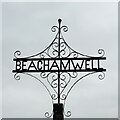
Beachamwell village sign
Beachamwell has a simple yet attractive metal scrollwork sign.
Image: © Adrian S Pye
Taken: 8 Apr 2021
0.11 miles
4
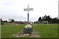
Beachamwell village sign
Beachamwell has a simple yet attractive metal scrollwork sign.
https://www.geograph.org.uk/photo/6803790
Image: © Adrian S Pye
Taken: 8 Apr 2021
0.11 miles

6

Village Green, Beachamwell
With the 'Great Danes' public house standing at the east end and currently decked out in support of some football match due to take place in warmer climes. This pub used to be called the Coopers' Arms no doubt reflecting an old industry in the village. Why change the name?
Image: © Mick Garratt
Taken: 10 Jun 2010
0.12 miles
7

Beachamwell Village Hall
Beachamwell is a small village west of Swaffham. Many prehistoric tools, Saxon jewellery and Roman coins have been unearthed in the area and there are also the remains of two medieval crosses bearing witness to regular markets having taken place on the village green and at the crossroads. There once used to be four churches of which only one, St Mary's > http://www.geograph.org.uk/photo/1269098 remains intact. Until the 1960’s almost all the villagers were employed by the estate.
Image: © Evelyn Simak
Taken: 22 Apr 2009
0.12 miles
8

The Great Danes country inn by the green
Village Inn offering accommodation with a Licensed Restaurant and Bar.
Image: © Carole Gransden
Taken: 18 Jun 2009
0.13 miles
9

Pub on the corner
The Great Danes public house > http://www.geograph.org.uk/photo/1269076 is located by the village green. Beachamwell is a small village west of Swaffham. Many prehistoric tools, Saxon jewellery and Roman coins have been unearthed in the area and there are also the remains of two medieval crosses bearing witness to regular markets having taken place on the village green and at the crossroads. There once used to be four churches of which only one, St Mary's > http://www.geograph.org.uk/photo/1269098 remains intact. Until the 1960’s almost all the villagers were employed by the estate.
Image: © Evelyn Simak
Taken: 22 Apr 2009
0.13 miles
10

The village green
Beachamwell is a small village west of Swaffham. Many prehistoric tools, Saxon jewellery and Roman coins have been unearthed in the area and there are also the remains of two medieval crosses bearing witness to regular markets having taken place on the village green and at the crossroads. There once used to be four churches of which only one, St Mary's > http://www.geograph.org.uk/photo/1269098 remains intact. Until the 1960’s almost all the villagers were employed by the estate.
Image: © Evelyn Simak
Taken: 22 Apr 2009
0.14 miles