
IMAGES TAKEN NEAR TO
Station Street, SWAFFHAM, PE37 7HP
Introduction
This page details the photographs taken nearby to Station Street, PE37 7HP by members of the Geograph project.
The Geograph project started in 2005 with the aim of publishing, organising and preserving representative images for every square kilometre of Great Britain, Ireland and the Isle of Man.

There are currently over 7.5m images from over14,400 individuals and you can help contribute to the project by visiting https://www.geograph.org.uk
Image Map
Images are licensed for reuse under creativecommons.org/licenses/by-sa/2.0
Notes
- Clicking on the map will re-center to the selected point.
- The higher the marker number, the further away the image location is from the centre of the postcode.
Image Listing (308 Images Found)
Images are licensed for reuse under creativecommons.org/licenses/by-sa/2.0
Image
Details
Distance

2
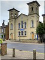
Swaffham Baptist Church
Swaffham Baptist Church is on Station Street. Built in 1858, this huge building, with its twin towered façade, is a stark contrast with Image built across the road approximately 100 years later.
Image: © David Dixon
Taken: 4 Aug 2015
0.02 miles

4

The Catholic Church of Our Lady of Pity
Our Lady of Pity is typical of the late 1950s style of Catholic churches, with tall arched windows, red brick walls and a high pitched roof.
http://www.norfolkchurches.co.uk/swaffhamrc/swaffhamrc.htm Norfolk Churches
Image: © David Dixon
Taken: 4 Aug 2015
0.03 miles
5

Swaffham Baptist Church
Grade II listed. http://www.britishlistedbuildings.co.uk/en-460658-baptist-chapel-and-hall-swaffham-norfolk
Image: © N Chadwick
Taken: 28 Dec 2013
0.03 miles
6

Swaffham, The Station
The public house was previously called "the Norfolk Hero".
The current name reminds us that Swaffham station was situated close to here; its position is shown on the OS map of 1946 http://www.npemap.org.uk/tiles/map.html#582,309,1. An Anglia TV report shows the station in 1963 when it was threated with closure http://www.eafa.org.uk/catalogue/213956 . It was finally closed in 1968.
Image: © David Dixon
Taken: 4 Aug 2015
0.03 miles
7

Swaffham, Our Lady of Pity Catholic Church
Our Lady of Pity is typical of the late 1950s style of Catholic churches, with tall arched windows, red brick walls and a high pitched roof.
http://www.norfolkchurches.co.uk/swaffhamrc/swaffhamrc.htm Norfolk
Image: © David Dixon
Taken: 4 Aug 2015
0.03 miles
8

The Station Public House, Swaffham
The public house was previously called "the Norfolk Hero".
The current name reminds us that Swaffham station was situated close to here; its position is shown on the OS map of 1946 http://www.npemap.org.uk/tiles/map.html#582,309,1. An Anglia TV report shows the station in 1963 when it was threated with closure http://www.eafa.org.uk/catalogue/213956 . It was finally closed in 1968.
Image: © David Dixon
Taken: 4 Aug 2015
0.04 miles
9

Swaffham (Norfolk) Our Lady of Pity's Catholic Church
Image: © ChurchCrawler
Taken: 14 Jun 2003
0.10 miles
