
IMAGES TAKEN NEAR TO
Kent Road, PETERBOROUGH, PE3 6DG
Introduction
This page details the photographs taken nearby to Kent Road, PE3 6DG by members of the Geograph project.
The Geograph project started in 2005 with the aim of publishing, organising and preserving representative images for every square kilometre of Great Britain, Ireland and the Isle of Man.

There are currently over 7.5m images from over14,400 individuals and you can help contribute to the project by visiting https://www.geograph.org.uk
Image Map
Images are licensed for reuse under creativecommons.org/licenses/by-sa/2.0
Notes
- Clicking on the map will re-center to the selected point.
- The higher the marker number, the further away the image location is from the centre of the postcode.
Image Listing (342 Images Found)
Images are licensed for reuse under creativecommons.org/licenses/by-sa/2.0
Image
Details
Distance
1

Peterborough District Hospital
The Postgraduate Medical Centre contains classrooms, meeting rooms and the Hospital' Laxton Library. It is towards the rear of the site, just off Midland Road.
Image: © Andy Parrett
Taken: 8 Jun 2009
0.04 miles
2
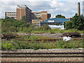
Peterborough: Post Graduate Medical Centre
A view from the station across disused railway sidings and waste ground.
Image: © Stephen Craven
Taken: 8 Aug 2011
0.06 miles
3

Peterborough District Hospital Sutton Wing
A modern part of the former district hospital on Alderman's Drive.
Peterborough district hospital closed in December 2010. The future of this site is uncertain but potentially demolition and new housing will emerge when economic conditions improve.
An outline planning proposal for the Hospital Quarter can be viewed here http://www.peterborough.gov.uk/pdf/Plan-policy-Hosp%20SPD%20-%20Master%20Copy%20-%20Final%20Adopted%2014.6.10.pdf
Image: © Michael Trolove
Taken: 20 Mar 2011
0.07 miles
4

Park at junction of Midland Road and Rathbone Crescent
In 1926 the land here was allotments, but by 1965 a bakery and dairy was on the site with an Ordnance Survey cut mark benchmark levelled at 12.536m above Newlyn Datum on the bakery building www.bench-marks.org.uk/bm117613 . The buildings were demolished in 2011 Image, and the area redeveloped.
Image: © Roger Templeman
Taken: 16 Sep 2018
0.07 miles
5

Peterborough District Hospital
The former District Hospital, due for redevelopment.
Seen from the roof of the Queensgate car park.
Image: © Bob Harvey
Taken: 17 Dec 2013
0.08 miles
6

Model Bakery on Midland Road
The redundant bakery now fire damaged and vandalised awaiting demolition along with a dairy next door.
Image: © Michael Trolove
Taken: 13 Mar 2011
0.08 miles
7

Peterborough District Hospital main entrance
Empty car parks, empty buildings, empty wards, empty hospital.
Peterborough district hospital closed in December 2010. The future of this site is uncertain but potentially demolition and new housing will emerge when economic conditions improve.
An outline planning proposal for the Hospital Quarter can be viewed here
http://www.peterborough.gov.uk/pdf/Plan-policy-Hosp%20SPD%20-%20Master%20Copy%20-%20Final%20Adopted%2014.6.10.pdf
Image: © Michael Trolove
Taken: 20 Mar 2011
0.08 miles
8

Former District Hospital on Alderman's Drive
Closed for business in December 2010 with all accident and emergency transferred to the new £335 million City hospital at Bretton Gate. Now a vast empty shell with an unclear future at this time of writing.
Image: © Michael Trolove
Taken: 13 Mar 2011
0.08 miles
9

The former Peterborough District Hospital outpatients entrance
The district hospital closed formerly on 7th December 2010 with all services transferred to the new £335 million City hospital at Bretton Gate. This leaves a large site with an unsure future but likely to be housing after demolition.
An outline planning proposal for the Hospital Quarter can be viewed here http://www.peterborough.gov.uk/pdf/Plan-policy-Hosp%20SPD%20-%20Master%20Copy%20-%20Final%20Adopted%2014.6.10.pdf
Image: © Michael Trolove
Taken: 13 Mar 2011
0.09 miles
10

The derelict Dairy Crest dairy, Midland Road
Graffiti strewn, fire damaged and vandalised, the former Co-op built dairy awaits the attention of a demolition contractor along with the Model Bakery next door and probably the former district hospital almost directly opposite. So a radical reshaping of a large area of land near the city centre.
Image: © Michael Trolove
Taken: 13 Mar 2011
0.09 miles