
IMAGES TAKEN NEAR TO
Thorpe Road, PETERBOROUGH, PE3 6AN
Introduction
This page details the photographs taken nearby to Thorpe Road, PE3 6AN by members of the Geograph project.
The Geograph project started in 2005 with the aim of publishing, organising and preserving representative images for every square kilometre of Great Britain, Ireland and the Isle of Man.

There are currently over 7.5m images from over14,400 individuals and you can help contribute to the project by visiting https://www.geograph.org.uk
Image Map
Images are licensed for reuse under creativecommons.org/licenses/by-sa/2.0
Notes
- Clicking on the map will re-center to the selected point.
- The higher the marker number, the further away the image location is from the centre of the postcode.
Image Listing (131 Images Found)
Images are licensed for reuse under creativecommons.org/licenses/by-sa/2.0
Image
Details
Distance

2
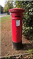
VR postbox on Thorpe Road, Peterborough
This VR pillar box (no. PE3 50D) is located next to the Sessions House, the city's former court house which now functions as a restaurant.
Image: © Paul Bryan
Taken: 5 Oct 2018
0.05 miles
3

Sessions House, Thorpe Road, Peterborough
The Sessions House was built in 1842 as part of Peterborough Gaol. The architect was WJ Donthorne. It is now a bar and restaurant. Peterborough District Hospital is in the background.
Image: © Julian Dowse
Taken: 20 Apr 2006
0.05 miles
4

Ordnance Survey Benchmark and Bolt - Peterborough, The Sessions House
Ordnance Survey Benchmark (OSBM) used for levelling height above Ordnance Datum (OD).
Height: 11.5611m OD (Newlyn). Mark verified by the Ordnance Survey in 1965. Description: NBM W SIDE ENT THE SESSIONS HOUSE N SIDE THORPE RD. 0.3m above ground. 3rd Order BM.
The bolt was included as a branch level from mark 139 on the Towcester to King's Lynn line of the First Primary Levelling of England & Wales in 1852. It was levelled with a height of 38.747’ above OD (Liverpool). Description: Peterborough New Gaol. Bolt in West side of door at main entrance ; 1.11 ft. above surface. Page 314 of the abstract: http://www.trigtools.co.uk/data/1GL/1GLA_314.png
Context: Image
Image: © N Scott
Taken: 15 Jan 2016
0.05 miles
5

Ordnance Survey Benchmark and Bolt - Peterborough, The Sessions House
Ordnance Survey Benchmark (OSBM) used for levelling height above Ordnance Datum (OD).
Height: 11.5611m OD (Newlyn). Mark verified by the Ordnance Survey in 1965. Description: NBM W SIDE ENT THE SESSIONS HOUSE N SIDE THORPE RD. 0.3m above ground. 3rd Order BM.
The bolt was included as a branch level from mark 139 on the Towcester to King's Lynn line of the First Primary Levelling of England & Wales in 1852. It was levelled with a height of 38.747’ above OD (Liverpool). Description: Peterborough New Gaol. Bolt in West side of door at main entrance ; 1.11 ft. above surface. Page 314 of the abstract: http://www.trigtools.co.uk/data/1GL/1GLA_314.png
Close-up: Image
Image: © N Scott
Taken: 15 Jan 2016
0.05 miles
6

1852 benchmark on Sessions House
Ordnance Survey 1GL bolt benchmark described on the Bench Mark Database at www.bench-marks.org.uk/bm79255
Image: © phil Richards
Taken: 23 Sep 2017
0.05 miles
7

Sessions House, Thorpe Road
There is an Ordnance Survey benchmark Image on the left hand side of the entrance doorway
Image: © phil Richards
Taken: 23 Sep 2017
0.05 miles
8

Ordnance Survey PA Bolt Benchmark - Peterborough, The Sessions House
Ordnance Survey Benchmark (OSBM) used for levelling height above Ordnance Datum (OD).
Height: 11.5611m OD (Newlyn). Mark verified by the Ordnance Survey in 1965. Description: NBM W SIDE ENT THE SESSIONS HOUSE N SIDE THORPE RD. 0.3m above ground. 3rd Order BM. TL 1837 9866
The bolt was included as a branch level from mark 139 on the Towcester to King's Lynn line of the First Primary Levelling of England & Wales in 1852. It was levelled with a height of 38.747’ above OD (Liverpool). Description: Peterborough New Gaol. Bolt in West side of door at main entrance ; 1.11 ft. above surface. Page 314 of the abstract: https://www.bench-marks.org.uk/abstract/ew1gl/1GLA_314.png
Context: Image
Image: © N Scott
Taken: 8 Apr 2025
0.05 miles
9

Ordnance Survey PA Bolt Benchmark - Peterborough, The Sessions House
Ordnance Survey Benchmark (OSBM) used for levelling height above Ordnance Datum (OD).
Height: 11.5611m OD (Newlyn). Mark verified by the Ordnance Survey in 1965. Description: NBM W SIDE ENT THE SESSIONS HOUSE N SIDE THORPE RD. 0.3m above ground. 3rd Order BM. TL 1837 9866
The bolt was included as a branch level from mark 139 on the Towcester to King's Lynn line of the First Primary Levelling of England & Wales in 1852. It was levelled with a height of 38.747’ above OD (Liverpool). Description: Peterborough New Gaol. Bolt in West side of door at main entrance ; 1.11 ft. above surface. Page 314 of the abstract: https://www.bench-marks.org.uk/abstract/ew1gl/1GLA_314.png
Close-up: Image
Image: © N Scott
Taken: 8 Apr 2025
0.05 miles
10

Benchmark on #60 Thorpe Road
Ordnance Survey cut mark benchmark described on the Bench Mark Database at https://www.bench-marks.org.uk/bm89953
Image: © Roger Templeman
Taken: 12 Sep 2018
0.05 miles