
IMAGES TAKEN NEAR TO
The Green, HUNSTANTON, PE36 5AH
Introduction
This page details the photographs taken nearby to The Green, PE36 5AH by members of the Geograph project.
The Geograph project started in 2005 with the aim of publishing, organising and preserving representative images for every square kilometre of Great Britain, Ireland and the Isle of Man.

There are currently over 7.5m images from over14,400 individuals and you can help contribute to the project by visiting https://www.geograph.org.uk
Image Map
Images are licensed for reuse under creativecommons.org/licenses/by-sa/2.0
Notes
- Clicking on the map will re-center to the selected point.
- The higher the marker number, the further away the image location is from the centre of the postcode.
Image Listing (362 Images Found)
Images are licensed for reuse under creativecommons.org/licenses/by-sa/2.0
Image
Details
Distance
1

Elizabeth II postbox on Cliff Parade, Hunstanton
Postbox No. PE36 335.
See Image] for context.
Image: © JThomas
Taken: 17 Oct 2017
0.02 miles
2

Greevegate, Hunstanton
The Tourist Information Centre, which overlooks The Green.
Image: © Dave Hitchborne
Taken: 14 Aug 2009
0.03 miles
3

Greevegate, Hunstanton
Looking across Greevegate to High Street.
Image: © Dave Hitchborne
Taken: 14 Aug 2009
0.03 miles
4

High Street, Hunstanton
The main shopping area.
Image: © Dave Hitchborne
Taken: 14 Aug 2009
0.03 miles
5

Greevegate, Hunstanton
'Upper' Greevegate.
Image: © Dave Hitchborne
Taken: 14 Aug 2009
0.03 miles
6

Greevegate, Hunstanton
'Lower' Greevegate, looking towards The Wash.
Image: © Dave Hitchborne
Taken: 14 Aug 2009
0.03 miles
7

Greevegate, Hunstanton
Hunstanton's shops.
Image: © Dave Hitchborne
Taken: 14 Aug 2009
0.03 miles

9

Hunstanton Sign
Armorial and pictorial sign on the Green in central Hunstanton. The Golden Lion Hotel is in the background.
Image: © Colin Smith
Taken: 25 Mar 2011
0.03 miles
10
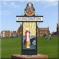
Hunstanton town sign
The sign in the shape of a “T” denotes the fact Hunstanton is a town, not a village. The sign is surmounted by a heraldic device, with the motto “alios delectare iuvat” which translates as “it is our pleasure to please.” Above is the crown of St Edmund, pierced with two arrows, The sea is represented by the blue wavy lines and above is a lion passant for England. The crest is a helm. Below the name is St Edmund himself with the wolf which guarded his body when he was killed by the Danes. The church is dedicated to St Edmund but Edmund has other connections. When his father, Æthelweard of East Anglia died in 854, Edmund, although only 14 years old, sailed for East Anglia to claim his inherited land. He arrived just North of Hunstanton. For the next 14 years he was a model King and then in the year 869AD a great army of Danes attacked from the North. Stories tell how the victorious heathen Danes tried to force Edmund to renounce his Christian beliefs, but he refused. So they tied him up and used him for target practice. According to legend, a wolf guarded his body until it could be buried in a shrine in what is known today as Bury St Edmund's. The village sign in Hunstanton depicts St Edmund's arrival in East Anglia and the wolf that protected his body after his martyrdom. Both sides are identical.
Image: © Adrian S Pye
Taken: 31 Mar 2021
0.03 miles