
IMAGES TAKEN NEAR TO
Cotts Lane, KING'S LYNN, PE34 4SL
Introduction
This page details the photographs taken nearby to Cotts Lane, PE34 4SL by members of the Geograph project.
The Geograph project started in 2005 with the aim of publishing, organising and preserving representative images for every square kilometre of Great Britain, Ireland and the Isle of Man.

There are currently over 7.5m images from over14,400 individuals and you can help contribute to the project by visiting https://www.geograph.org.uk
Image Map
Images are licensed for reuse under creativecommons.org/licenses/by-sa/2.0
Notes
- Clicking on the map will re-center to the selected point.
- The higher the marker number, the further away the image location is from the centre of the postcode.
Image Listing (120 Images Found)
Images are licensed for reuse under creativecommons.org/licenses/by-sa/2.0
Image
Details
Distance

2

Postbox and K6 telephone box in Church Road
Postbox and telephone box are situated by the village hall > http://www.geograph.org.uk/photo/1821797.
Image: © Evelyn Simak
Taken: 21 Apr 2010
0.04 miles
3

Elizabeth II postbox and telephone box on Church Road, Tilney All Saints
Showing position of Postbox No. PE34 119.
See Image] for postbox.
Image: © JThomas
Taken: 5 Oct 2020
0.05 miles
4

Church Road, Tilney All Saints
Showing position of Postbox No. PE34 119.
See Image] for postbox.
Image: © JThomas
Taken: 5 Oct 2020
0.05 miles
5

Elizabeth II postbox on Church Road, Tilney All Saints
Image: © JThomas
Taken: 5 Oct 2020
0.05 miles


9

Cottages opposite All Saints church
The churchyard gate can be seen in the foreground. For a view of the church see > http://www.geograph.org.uk/photo/1821811.
Image: © Evelyn Simak
Taken: 21 Apr 2010
0.07 miles
10
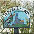
Tilney All Saints village sign
The sign depicts Tom Hinkathrift who was a strong fellow and by removing a wheel from his cart to use as a shield and using the axle as a weapon beat the giant who was trying to steal the beer he was carting. In truth, Tom Hinkathrift was an exceptionally strong and tall man who fought against oppression and created a legend for himself. He is buried in Tilney All Saints churchyard. He is also depicted on Marshland St James village sign. https://www.geograph.org.uk/photo/6733605 The sign also shows All Saints parish church. The wheat and carrot represent the crops grown hereabouts and agricultural community. https://www.geograph.org.uk/photo/6815184
Image: © Adrian S Pye
Taken: 18 Apr 2021
0.07 miles