IMAGES TAKEN NEAR TO
Bennett Close, KING'S LYNN, PE33 0TF
Introduction
This page details the photographs taken nearby to Bennett Close, PE33 0TF by members of the Geograph project.
The Geograph project started in 2005 with the aim of publishing, organising and preserving representative images for every square kilometre of Great Britain, Ireland and the Isle of Man.

There are currently over 7.5m images from over14,400 individuals and you can help contribute to the project by visiting https://www.geograph.org.uk
Image Map
Images are licensed for reuse under creativecommons.org/licenses/by-sa/2.0
Notes
- Clicking on the map will re-center to the selected point.
- The higher the marker number, the further away the image location is from the centre of the postcode.
Image Listing (63 Images Found)
Images are licensed for reuse under creativecommons.org/licenses/by-sa/2.0
Image
Details
Distance
2
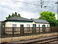
Watlington Station - former toilets
Watlington railway station lies on the Fen Line from Cambridge to King's Lynn, which is electrified at 25 kV AC overhead. The station used to be part of the East Anglian Railway but in 1862 it was incorporated into the Great Eastern Railway. The branch was closed in 1969 along with its station but thanks to local efforts the station was re-opened in 1975, and the old signal box (it has retained its old Network SouthEast sign with its old name) is still in use today > http://www.geograph.org.uk/photo/1390248. The platform by the signal box dates from the 1990s, the original station buildings on the other side of Station Road have been converted into private housing. Presently the station is served by 'First Capital Connect' which runs from King's Cross, London, to King's Lynn.
Image: © Evelyn Simak
Taken: 7 Jul 2009
0.14 miles
3
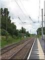
Watlington Station - view south from platform 2
For a view of platform 2 see > http://www.geograph.org.uk/photo/1390206.
Watlington railway station lies on the Fen Line from Cambridge to King's Lynn, which is electrified at 25 kV AC overhead. The station used to be part of the East Anglian Railway but in 1862 it was incorporated into the Great Eastern Railway. The branch was closed in 1969 along with its station but thanks to local efforts the station was re-opened in 1975, and the old signal box (it has retained its old Network SouthEast sign with its old name) is still in use today > http://www.geograph.org.uk/photo/1390248. The platform by the signal box dates from the 1990s, the original station buildings on the other side of Station Road have been converted into private housing. Presently the station is served by 'First Capital Connect' which runs from King's Cross, London to King's Lynn.
Image: © Evelyn Simak
Taken: 7 Jul 2009
0.15 miles
4

Watlington Station - this way to Cambridge
View south along railway tracks past platform 2. The gable end of the former station building can be seen at left. Watlington railway station lies on the Fen Line from Cambridge to King's Lynn, which is electrified at 25 kV AC overhead. The station used to be part of the East Anglian Railway but in 1862 it was incorporated into the Great Eastern Railway. The branch was closed in 1969 along with its station but thanks to local efforts the station was re-opened in 1975, and the old signal box (it has retained its old Network SouthEast sign with its old name) is still in use today > http://www.geograph.org.uk/photo/1390248. The platform by the signal box dates from the 1990s, the original station buildings on the other side of Station Road have been converted into private housing. Presently the station is served by 'First Capital Connect' which runs from King's Cross, London, to King's Lynn.
Image: © Evelyn Simak
Taken: 7 Jul 2009
0.15 miles
5

Watlington railway station, Norfolk
Opened in 1846 by the Lynn & Ely Railway, later part of the Great Eastern Railway, on the line from Kings Lynn to Ely, this station was renamed Magdalen Road in 1875. The station closed in 1968 but was reopened in 1975, still as Magdalen Road. It reverted to its original name of Watlington in 1989.
View north towards St Germain's and Kings Lynn, on the northbound platform. The southbound platform used to be opposite this, but was moved to the current location in the distance, in the early 1990s.
Image: © Nigel Thompson
Taken: 8 Oct 2016
0.16 miles
7

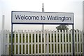
Level crossing on Station Road
The railway station is right beside the level crossing with one platform to the south > http://www.geograph.org.uk/photo/1390206 and the other north of Station Road.
Image: © Evelyn Simak
Taken: 7 Jul 2009
0.16 miles