
IMAGES TAKEN NEAR TO
School Road, KING'S LYNN, PE33 0EN
Introduction
This page details the photographs taken nearby to School Road, PE33 0EN by members of the Geograph project.
The Geograph project started in 2005 with the aim of publishing, organising and preserving representative images for every square kilometre of Great Britain, Ireland and the Isle of Man.

There are currently over 7.5m images from over14,400 individuals and you can help contribute to the project by visiting https://www.geograph.org.uk
Image Map
Images are licensed for reuse under creativecommons.org/licenses/by-sa/2.0
Notes
- Clicking on the map will re-center to the selected point.
- The higher the marker number, the further away the image location is from the centre of the postcode.
Image Listing (10 Images Found)
Images are licensed for reuse under creativecommons.org/licenses/by-sa/2.0
Image
Details
Distance
1

Field Barn Lane, South Runcton
Junction with the A10.
Image: © JThomas
Taken: 5 Oct 2020
0.08 miles
2

Elizabeth II postbox on Field Barn Lane, South Runcton
Postbox No. PE33 227.
See Image] for context.
Image: © JThomas
Taken: 5 Oct 2020
0.10 miles

4

Old Milestone
Old milestone the A.10 at South Runction, Norfolk. For overall view see http://www.geograph.org.uk/photo/2779926
Image: © Keith Evans
Taken: 26 Jan 2012
0.11 miles
5

Old Milestone
Old milestone was the A.10 at South Runcton, Norfolk. For close up view see http://www.geograph.org.uk/photo/2779918
Image: © Keith Evans
Taken: 26 Jan 2012
0.11 miles
6

Field Barn Lane, South Runcton
Showing position of Postbox No. PE33 227.
See Image] for postbox.
Image: © JThomas
Taken: 5 Oct 2020
0.11 miles
7

Old Milestone by the A10, Lynn Road, South Runcton
Carved stone post by the A10, in parish of RUNCTON HOLME (KINGS LYNN AND WEST NORFOLK District), Lynn Road, 140yds North of School Road, in hedgerow behind deep ditch, on West side of road. Kings Lynn gable, erected by the Lynn - South Gate turnpike trust in the 19th century.
Inscription reads:-
DOWNHAM
4
LYNN 7
Milestone Society National ID: NO_KLDM07.
Image: © MW Hallett
Taken: 28 Dec 2003
0.12 miles
8

Cottage at South Runcton
A pretty cottage east of the A10.
Image: © Robert Walden
Taken: 30 Sep 2007
0.12 miles
9

A10 heading north
Looking from a lay-by near South Runcton.
Image: © Robin Webster
Taken: 17 Feb 2018
0.15 miles
10
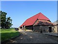
The Red Barn - South Runcton - Norfolk
This 16th century oak beamed medieval tythe barn is a spectacular venue for weddings and special events http://www.theredbarnnorfolk.co.uk/
Image: © Richard Humphrey
Taken: 8 Sep 2016
0.17 miles