
IMAGES TAKEN NEAR TO
The Square, KING'S LYNN, PE32 2SH
Introduction
This page details the photographs taken nearby to The Square, PE32 2SH by members of the Geograph project.
The Geograph project started in 2005 with the aim of publishing, organising and preserving representative images for every square kilometre of Great Britain, Ireland and the Isle of Man.

There are currently over 7.5m images from over14,400 individuals and you can help contribute to the project by visiting https://www.geograph.org.uk
Image Map
Images are licensed for reuse under creativecommons.org/licenses/by-sa/2.0
Notes
- Clicking on the map will re-center to the selected point.
- The higher the marker number, the further away the image location is from the centre of the postcode.
Image Listing (47 Images Found)
Images are licensed for reuse under creativecommons.org/licenses/by-sa/2.0
Image
Details
Distance
1

Direction Sign ? Signpost
Located on the east side of the T junction southeast of the church in Rougham parish. 3 arms and annulus finial.
Milestone Society National ID: NO_TF8320
Image: © J Young
Taken: 2 Aug 2004
0.02 miles
2

St Mary's church in Rougham - west doorway
For a view of the church see > http://www.geograph.org.uk/photo/1867757.
Image: © Evelyn Simak
Taken: 18 May 2010
0.04 miles
3

St Mary's church in Rougham - tower and south porch
For a full view of the church see > http://www.geograph.org.uk/photo/1867757.
Image: © Evelyn Simak
Taken: 18 May 2010
0.04 miles

5

Ordnance Survey Cut Mark
This heavily lichened mark can be found on the wall of St Mary's Church in Rougham.
For more detail see : http://www.bench-marks.org.uk/bm34440
Image: © Peter Wood
Taken: 9 Nov 2014
0.04 miles
6
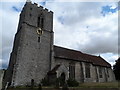
St Mary's Rougham (south side)
Dates from C14 but the north aisle was rebuilt in 1913.
Image: © Bikeboy
Taken: 18 Aug 2014
0.05 miles
7

St Mary's church in Rougham
The church of St Mary > http://www.geograph.org.uk/photo/1867757 dates mainly from the 13th century, the tower was added a century later. The original north aisle was demolished in the 1700s and replaced by a new one in 1913. The church still houses the original C14 font > http://www.geograph.org.uk/photo/1867827. On the south wall of the chancel a C15 carved panel > http://www.geograph.org.uk/photo/1867804 depicting saints and angels can be seen. The perhaps most noteworthy features are the 15th century figure brasses > http://www.geograph.org.uk/photo/1867817 commemorating members of the Yelverton family.
Image: © Evelyn Simak
Taken: 18 May 2010
0.05 miles
8

St Mary's church in Rougham - war memorial
The church of St Mary > http://www.geograph.org.uk/photo/1867757 dates mainly from the 13th century, the tower was added a century later. The original north aisle was demolished in the 1700s and replaced by a new one in 1913. The church still houses the original C14 font > http://www.geograph.org.uk/photo/1867827. On the south wall of the chancel a C15 carved panel > http://www.geograph.org.uk/photo/1867804 depicting saints and angels can be seen. The perhaps most noteworthy features are the 15th century figure brasses > http://www.geograph.org.uk/photo/1867817 commemorating members of the Yelverton family.
Image: © Evelyn Simak
Taken: 18 May 2010
0.05 miles
9

St Mary's church in Rougham - C14 baptismal font
The church of St Mary > http://www.geograph.org.uk/photo/1867757 dates mainly from the 13th century, the tower was added a century later. The original north aisle was demolished in the 1700s and replaced by a new one in 1913. The church still houses the original C14 font. On the south wall of the chancel a C15 carved panel > http://www.geograph.org.uk/photo/1867804 depicting saints and angels can be seen. The perhaps most noteworthy features are the 15th century figure brasses > http://www.geograph.org.uk/photo/1867817 commemorating members of the Yelverton family.
Image: © Evelyn Simak
Taken: 18 May 2010
0.05 miles
10

St Mary's church in Rougham - decalogue boards
The church of St Mary > http://www.geograph.org.uk/photo/1867757 dates mainly from the 13th century, the tower was added a century later. The original north aisle was demolished in the 1700s and replaced by a new one in 1913. The church still houses the original C14 font > http://www.geograph.org.uk/photo/1867827. On the south wall of the chancel a C15 carved panel > http://www.geograph.org.uk/photo/1867804 depicting saints and angels can be seen. The perhaps most noteworthy features are the 15th century figure brasses > http://www.geograph.org.uk/photo/1867817 commemorating members of the Yelverton family.
Image: © Evelyn Simak
Taken: 18 May 2010
0.05 miles