IMAGES TAKEN NEAR TO
Main Road, KING'S LYNN, PE32 1HP
Introduction
This page details the photographs taken nearby to Main Road, PE32 1HP by members of the Geograph project.
The Geograph project started in 2005 with the aim of publishing, organising and preserving representative images for every square kilometre of Great Britain, Ireland and the Isle of Man.

There are currently over 7.5m images from over14,400 individuals and you can help contribute to the project by visiting https://www.geograph.org.uk
Image Map
Images are licensed for reuse under creativecommons.org/licenses/by-sa/2.0
Notes
- Clicking on the map will re-center to the selected point.
- The higher the marker number, the further away the image location is from the centre of the postcode.
Image Listing (44 Images Found)
Images are licensed for reuse under creativecommons.org/licenses/by-sa/2.0
Image
Details
Distance
2
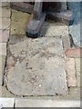
St Cecilia, West Bilney, Norfolk - Ledger Slab
Image: © John Salmon
Taken: 13 Feb 2008
0.07 miles
3
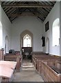
St Cecilia, West Bilney, Norfolk - West end
Image: © John Salmon
Taken: 13 Feb 2008
0.07 miles
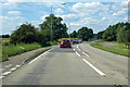
6
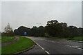
A47 entering West Bilney
Parking half a mile ahead.
Image: © J.Hannan-Briggs
Taken: 13 Jun 2016
0.11 miles
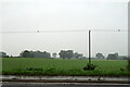
7
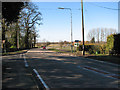
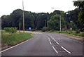
The A47 road past West Bilney
The junction with Paws Lane can be seen in the foreground (at left).
Image: © Evelyn Simak
Taken: 7 Mar 2010
0.18 miles
8
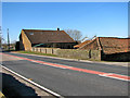
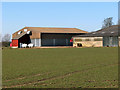
Barns on Church Farm in West Bilney
The road seen in the foreground is the A47.
Image: © Evelyn Simak
Taken: 7 Mar 2010
0.19 miles
10
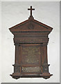
The WW1 War Memorial in West Bilney St. Cecelia's church
The Memorial bears the names of five men who went to war and never returned home
Image: © Adrian S Pye
Taken: 31 May 2019
0.20 miles