
IMAGES TAKEN NEAR TO
London Road, KING'S LYNN, PE30 5PT
Introduction
This page details the photographs taken nearby to London Road, PE30 5PT by members of the Geograph project.
The Geograph project started in 2005 with the aim of publishing, organising and preserving representative images for every square kilometre of Great Britain, Ireland and the Isle of Man.

There are currently over 7.5m images from over14,400 individuals and you can help contribute to the project by visiting https://www.geograph.org.uk
Image Map
Images are licensed for reuse under creativecommons.org/licenses/by-sa/2.0
Notes
- Clicking on the map will re-center to the selected point.
- The higher the marker number, the further away the image location is from the centre of the postcode.
Image Listing (1006 Images Found)
Images are licensed for reuse under creativecommons.org/licenses/by-sa/2.0
Image
Details
Distance

2

Methodist chapel in London Road, King's Lynn
Dated 1858-59 and built in the Italianate fashion of the time, it has a brick facade, round-arched windows in three bays and the centre bay projecting. Inside is a gallery on iron columns.
Image: © Evelyn Simak
Taken: 30 Apr 2011
0.03 miles
3

Methodist chapel in London Road, King's Lynn
Dated 1858-59 and built in the Italianate fashion of the time, it has a brick facade, round-arched windows in three bays and the centre bay projecting. Inside is a gallery on iron columns.
Image: © Evelyn Simak
Taken: 30 Apr 2011
0.03 miles
4

The war memorial in Tower Gardens, King's Lynn
The Methodist chapel in London Road can be seen in the background. The tower gardens once used to be a friary's orchard. When the friary was closed in 1538, the tower and the land surrounding it passed to the Town Council. The garden was designed in 1911 as a public park to commemorate the coronation of King George V. In 1921 it became the site of the town's war memorial. Previously, this part of Greyfriars was used to hold cattle awaiting market. The tower has since been completely restored and its gardens remodelled to show the extent of the 14th century Franciscan friary.
Image: © Evelyn Simak
Taken: 30 Apr 2011
0.03 miles
5
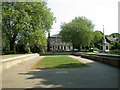
Tower Gardens, King's Lynn
This is a view across the site of the choir where the friars would have met and worshipped together. Archaeologists have discovered the footings for the choir stalls and a resonance chamber beneath them which would have amplified the sound of the friars' singing.
The tower gardens once used to be a friary's orchard. When the friary was closed in 1538, the tower and the land surrounding it passed to the Town Council. The garden was designed in 1911 as a public park to commemorate the coronation of King George V. In 1921 it became the site of the town's war memorial. Previously, this part of Greyfriars was used to hold cattle awaiting market. The tower has since been completely restored and its gardens remodelled to show the extent of the 14th century Franciscan friary.
Image: © Evelyn Simak
Taken: 30 Apr 2011
0.03 miles
6

Trail-Lynn around in search of a King (57)
Path running parallel to St James' Road
Image: © Basher Eyre
Taken: 25 Oct 2016
0.03 miles


9

Beware! This is a dangerous pavement
Pavement markings warning pedestrians about the possibility of traffic emerging from a blank wall. Google Streetview dated May 2017 showed a freshly built wall on the right, as part of other construction work on the nearby police station. The picture was taken at night - the only chance I had to record this danger spot.
Image: © David Smith
Taken: 17 Sep 2018
0.04 miles
10

Carnegie library, King's Lynn
Funded and opened by the great philanthropist himself. Built with carstone and brick.
Image: © Tim Heaton
Taken: 8 Aug 2009
0.04 miles