
IMAGES TAKEN NEAR TO
Lynn Road, KING'S LYNN, PE30 4PX
Introduction
This page details the photographs taken nearby to Lynn Road, PE30 4PX by members of the Geograph project.
The Geograph project started in 2005 with the aim of publishing, organising and preserving representative images for every square kilometre of Great Britain, Ireland and the Isle of Man.

There are currently over 7.5m images from over14,400 individuals and you can help contribute to the project by visiting https://www.geograph.org.uk
Image Map
Images are licensed for reuse under creativecommons.org/licenses/by-sa/2.0
Notes
- Clicking on the map will re-center to the selected point.
- The higher the marker number, the further away the image location is from the centre of the postcode.
Image Listing (40 Images Found)
Images are licensed for reuse under creativecommons.org/licenses/by-sa/2.0
Image
Details
Distance

2

Footpath off Lynn Road, Gaywood
Leading to King John Avenue.
Image: © Richard Vince
Taken: 20 Sep 2025
0.03 miles

4

Pedestrian access to Tesco superstore, Gaywood
Providing a route between Lynn Road and the superstore entrance that avoids most of the car park.
Image: © Richard Vince
Taken: 20 Sep 2025
0.05 miles
5

Footpath and cycleway off Lynn Road, Gaywood
A multi use path on the trackbed of the former railway line from King's Lynn towards Hunstanton and Wells. Looking towards North Wootton from what would have been a level crossing across Lynn Road.
Image: © Richard Vince
Taken: 20 Sep 2025
0.06 miles
6
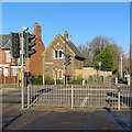
King's Lynn: where trains once crossed
This is where the Sandringham Railway Path crosses Gaywood Road. Until 1969 this was the route of the Lynn to Hunstanton railway and the house in the centre was a crossing-keeper's cottage.
Image: © John Sutton
Taken: 18 Nov 2018
0.06 miles
7
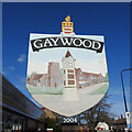
Gaywood village sign
Gaywood has become part of the town of King's Lynn. The sign which stands almost directly opposite the WWI Memorial Clock which is the central object in the picture. The church of St Faith is depicted on the left and the parade of shops known as Bishop’s Terrace, on the right. The coat of arms surmounting the sign belongs to the Bagge family who had seats in Islington, Stradsett and Gaywood. https://www.geograph.org.uk/photo/6813476
Image: © Adrian S Pye
Taken: 18 Apr 2021
0.10 miles
8

Gaywood village sign
Gaywood has become an extension of the town of King's Lynn. The sign which stands almost directly opposite the WWI Memorial Clock which is the central object in the picture. The church of St Faith is depicted on the left and the parade of shops known as Bishop’s Terrace, on the right. The coat of arms surmounting the sign belongs to the Bagge family who had seats in Islington, Stradsett and Gaywood. https://www.geograph.org.uk/photo/6813473
Image: © Adrian S Pye
Taken: 18 Apr 2021
0.10 miles
9

Gaywood Clock Tower
Erected in 1920 as a war memorial, this clock tower is located near a busy junction on Lynn Road.
Image: © Mat Fascione
Taken: 25 Aug 2013
0.11 miles
10

Bishop's Terrace, Gaywood
Mid C16 building at the busy complex of road junctions in the centre of Gaywood. Something interesting to look at as you wait at the traffic lights on the way into King's Lynn. Grade II listed - see http://www.imagesofengland.org.uk/search/details.aspx?pid=2&id=384204 for more information.
Image: © Nigel Jones
Taken: 3 Jun 2007
0.12 miles