
IMAGES TAKEN NEAR TO
Hamlin Way, KING'S LYNN, PE30 4NG
Introduction
This page details the photographs taken nearby to Hamlin Way, PE30 4NG by members of the Geograph project.
The Geograph project started in 2005 with the aim of publishing, organising and preserving representative images for every square kilometre of Great Britain, Ireland and the Isle of Man.

There are currently over 7.5m images from over14,400 individuals and you can help contribute to the project by visiting https://www.geograph.org.uk
Image Map
Images are licensed for reuse under creativecommons.org/licenses/by-sa/2.0
Notes
- Clicking on the map will re-center to the selected point.
- The higher the marker number, the further away the image location is from the centre of the postcode.
Image Listing (3 Images Found)
Images are licensed for reuse under creativecommons.org/licenses/by-sa/2.0
Image
Details
Distance
1

Ditch on The Hardwick Industrial Estate, King's Lynn
Image: © Richard Humphrey
Taken: 10 Sep 2010
0.02 miles
2
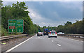
A47 approaches junction with A149 and A10
Heading east at Kings Lynn.
Image: © J.Hannan-Briggs
Taken: 13 Jun 2016
0.16 miles
3

Disused trackbed, South Lynn
Until 1959, a short section of railway, of which this is a part, carried a shuttle service from King's Lynn's still-extant station to the former Midland & Great Northern Joint Railway station at South Lynn, from where one could catch services towards Norwich in one direction and Spalding in the other. This photograph is taken a few metres from where the line joined the current Network Rail line from Ely.
After the end of passenger services on the "Joint", a section of this line was left open into the 1980s transporting materials to the sugar beet factory in South Lynn. The line is now mostly lifted west of this point.
Image: © Lewis Collard
Taken: Unknown
0.19 miles