
IMAGES TAKEN NEAR TO
Hardwick Road, KING'S LYNN, PE30 4HR
Introduction
This page details the photographs taken nearby to Hardwick Road, PE30 4HR by members of the Geograph project.
The Geograph project started in 2005 with the aim of publishing, organising and preserving representative images for every square kilometre of Great Britain, Ireland and the Isle of Man.

There are currently over 7.5m images from over14,400 individuals and you can help contribute to the project by visiting https://www.geograph.org.uk
Image Map
Images are licensed for reuse under creativecommons.org/licenses/by-sa/2.0
Notes
- Clicking on the map will re-center to the selected point.
- The higher the marker number, the further away the image location is from the centre of the postcode.
Image Listing (87 Images Found)
Images are licensed for reuse under creativecommons.org/licenses/by-sa/2.0
Image
Details
Distance
1

Railway into King's Lynn
View north east from Hardwick bridge on the A149.
Image: © JThomas
Taken: 30 Sep 2017
0.02 miles
2

Waterway leading to River Nar
A small waterway as it leaves King's Lynn, passes underneath the Hardwick Road (A149) and carries on its way to join the River Nar at South Lynn.
Image: © Martin Pearman
Taken: 14 Jun 2007
0.02 miles

4

McDonald's Drive-Through , Campbells Meadow, King's Lynn
Fast food and drive-through restaurant at the new retail park off the A149, to the south of King's Lynn.
Image: © David Dixon
Taken: 5 Aug 2015
0.07 miles
5

King's Lynn Borough Council Cemetery (south)
The main path through the southern section of the cemetery. The cemetery was opened in 1846 as a non-denominational extension to one of Kings Lynn's churches and then came under the control of Kings Lynn Burial Board in 1855, being one of the first municipal burial grounds in the country. The site is bisected by Hardwick Road and covers some 20 acres. It retains much of its arboretum layout. The chapels (still marked on OS maps) were demolished in the 1970's. The northern sections contain burials belonging to the parish of All Saints whereas the burials in the southern sections belong to the parish of St Margaret. Some of the sections are on un-consecrated ground, and one section has been given over to Roman Catholic burials.
Image: © Evelyn Simak
Taken: 30 Apr 2011
0.08 miles
6

King's Lynn Borough Council Cemetery (south)
Victorian headstones surrounded by elaborate wrought-iron railings in the shape of harps. The posts are topped by crowns and crosses.
The cemetery was opened in 1846 as a non-denominational extension to one of Kings Lynn's churches and then came under the control of Kings Lynn Burial Board in 1855, being one of the first municipal burial grounds in the country. The site is bisected by Hardwick Road and covers some 20 acres. It retains much of its arboretum layout. The chapels (still marked on OS maps) were demolished in the 1970's. The northern sections contain burials belonging to the parish of All Saints whereas the burials in the southern sections belong to the parish of St Margaret. Some of the sections are on un-consecrated ground, and one section has been given over to Roman Catholic burials.
Image: © Evelyn Simak
Taken: 30 Apr 2011
0.08 miles
7

Hardwick Road leaving King's Lynn
The Hardwick Road (A149) as it leaves King's Lynn.
Ahead is the Hardwick Bridge which carries the road over the King's Lynn to London railway line.
In the distance can be seen the Campbell's Tower. http://www.geograph.org.uk/photo/466907
Image: © Martin Pearman
Taken: 14 Jun 2007
0.09 miles
8
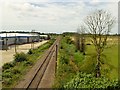
Railway Track at Campbells Meadow
Single track railway on the northern edge of the new retail park off the A149, south of King's Lynn.
Image: © David Dixon
Taken: 5 Aug 2015
0.10 miles

10
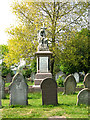
King's Lynn Borough Council Cemetery (south)
The tall monument seen in the background marks the grave of engineer Frederick Savage (d 1897). He began his career at sixteen, working for Thomas Cooper who was a Whitesmith and Machine Maker, and later for John and James Gill who were Millwrights and Machine Makers, where he gained a considerable amount of experience and knowledge about the manfucture of farm implements with the firm. After his marriage he took employment with Charles Willett, a "Brazier, Whitesmith, Iron Monger, Wholesale and Retail Dealer, Tinplate worker, and Bell Hanger". After Mr Willett's retirement, Frederick Savage set himself up in business as a smithy. The business grew and by now Savage referred to himself as "Engineer and Agricultural Machinist"
Frederick Savage was appointed as "Justice of the Peace" (JP) and was Mayor of King's Lynn in 1889-90. A monument to him was unveiled on the 27th of May 1892 - it is the only monument to a public man in Kings Lynn.
The cemetery was opened in 1846 as a non-denominational extension to one of Kings Lynn's churches and then came under the control of Kings Lynn Burial Board in 1855, being one of the first municipal burial grounds in the country. The site is bisected by Hardwick Road and covers some 20 acres. It retains much of its arboretum layout. The chapels (still marked on OS maps) were demolished in the 1970's. The northern sections contain burials belonging to the parish of All Saints whereas the burials in the southern sections belong to the parish of St Margaret. Some of the sections are on un-consecrated ground, and one section has been given over to Roman Catholic burials.
Image: © Evelyn Simak
Taken: 30 Apr 2011
0.10 miles