
IMAGES TAKEN NEAR TO
Sir Lewis Street, KING'S LYNN, PE30 2AL
Introduction
This page details the photographs taken nearby to Sir Lewis Street, PE30 2AL by members of the Geograph project.
The Geograph project started in 2005 with the aim of publishing, organising and preserving representative images for every square kilometre of Great Britain, Ireland and the Isle of Man.

There are currently over 7.5m images from over14,400 individuals and you can help contribute to the project by visiting https://www.geograph.org.uk
Image Map
Images are licensed for reuse under creativecommons.org/licenses/by-sa/2.0
Notes
- Clicking on the map will re-center to the selected point.
- The higher the marker number, the further away the image location is from the centre of the postcode.
Image Listing (47 Images Found)
Images are licensed for reuse under creativecommons.org/licenses/by-sa/2.0
Image
Details
Distance
1
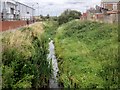
King's Lynn, Bawsey Drain
Bawsey Drain is one of four strategic watercourses which protect the town of King’s Lynn from surface water flooding during periods of significant rainfall. The others are: The Gaywood River; the North Lynn Drain; and the Pierrepoint/Middleton Stop system. Between them, they carry most of the water that rains on King’s Lynn through to the sea defences and out into The Wash.
Image: © David Dixon
Taken: 5 Aug 2015
0.03 miles


4

Edward Benefer Way in King's Lynn
On the right is the grain storage tower at the Bentinck Dock, the tallest structure in King's Lynn.
Image: © Mat Fascione
Taken: 26 Aug 2013
0.07 miles


7
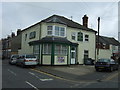
The Bentinck Arms, King's Lynn
On Loke Road.
Lord George Bentinck was a member of Parliament for King's Lynn, 1828–1848.
Image: © JThomas
Taken: 16 Sep 2017
0.09 miles

9

Tower at the port of King's Lynn
The docks are on the River Ouse the other side of the fence.
Image: © David Howard
Taken: 2 May 2021
0.11 miles
10

Tower at the port of King's Lynn
From Wickes car park
Image: © David Howard
Taken: 2 May 2021
0.12 miles