
IMAGES TAKEN NEAR TO
Jubilee Court, KING'S LYNN, PE30 1JG
Introduction
This page details the photographs taken nearby to Jubilee Court, PE30 1JG by members of the Geograph project.
The Geograph project started in 2005 with the aim of publishing, organising and preserving representative images for every square kilometre of Great Britain, Ireland and the Isle of Man.

There are currently over 7.5m images from over14,400 individuals and you can help contribute to the project by visiting https://www.geograph.org.uk
Image Map
Images are licensed for reuse under creativecommons.org/licenses/by-sa/2.0
Notes
- Clicking on the map will re-center to the selected point.
- The higher the marker number, the further away the image location is from the centre of the postcode.
Image Listing (1632 Images Found)
Images are licensed for reuse under creativecommons.org/licenses/by-sa/2.0
Image
Details
Distance
1

Detail of 17 Queen Street, King's Lynn
Early C18th doorcase with a lovely pair of barley-sugar columns.
Image: © Stephen Richards
Taken: 12 Jul 2015
0.01 miles
2

King's Lynn, 17 Queen Street: 'Clifton House' with its distinctive barley-sugar columns
Image: © Michael Garlick
Taken: 25 Sep 2023
0.01 miles
3
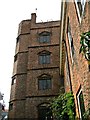
Clifton House watchtower
Elizabethan watchtower on former merchants house now hidden behind 18C frontage.
Image: © John M
Taken: 13 Sep 2015
0.01 miles
4
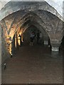
Undercroft at Clifton House
Early brick built undercroft from c1350 providing storage for wine barrels brought in by tunnel from the quayside. Steps up to Queen Street allowed this to function as a wine shop.
Image: © John M
Taken: 13 Sep 2015
0.01 miles
5

Clifton House
The core of the house is 13th and 14th century. Partly rebuilt in the 16th and 17th centuries and refronted in 1708. There is a mid 14th century undercroft. Listed, grade I, with details at: https://www.historicengland.org.uk/listing/the-list/list-entry/1210377
Image: © Michael Dibb
Taken: 6 Sep 2016
0.01 miles
6
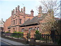
Queen Street, King's Lynn
Historic red brick buildings in central King's Lynn. This was an important Hanseatic trading port.
www.west-norfolk.gov.uk
Image: © Colin Smith
Taken: 25 Mar 2011
0.02 miles
7
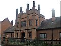
Burkitt Homes
Behind this wonderful entrance arch are 12 almshouses endowed by William Burkitt. Listed, grade II, with details at: https://www.historicengland.org.uk/listing/the-list/list-entry/1210433
Image: © Michael Dibb
Taken: 6 Sep 2016
0.02 miles
8

The Clifton House watchtower
Surprisingly hidden from the neighbouring streets, this late 16th century tower is visible from a residential courtyard reached through an arch.
Image: © Chris Brown
Taken: 3 Nov 2017
0.02 miles
9
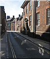
King's Lynn: Queen Street
Clear, low northern light reflected from high windows on to narrow lanes on an October morning briefly reminded me of the Old Town in Stockholm.
Image: © John Sutton
Taken: 6 Oct 2013
0.02 miles
10
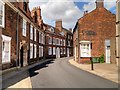
Queen Street (formerly known as Wingate Street)
Queen Street originally followed the bank of the river, with the houses on the east side facing the water; unfortunately, none of the mediæval houses survive today. The houses on the other side of the street were built later, as the river retreated west.
Image: © David Dixon
Taken: 5 Aug 2015
0.02 miles