
IMAGES TAKEN NEAR TO
Great Northern Street, HUNTINGDON, PE29 7HL
Introduction
This page details the photographs taken nearby to Great Northern Street, PE29 7HL by members of the Geograph project.
The Geograph project started in 2005 with the aim of publishing, organising and preserving representative images for every square kilometre of Great Britain, Ireland and the Isle of Man.

There are currently over 7.5m images from over14,400 individuals and you can help contribute to the project by visiting https://www.geograph.org.uk
Image Map
Images are licensed for reuse under creativecommons.org/licenses/by-sa/2.0
Notes
- Clicking on the map will re-center to the selected point.
- The higher the marker number, the further away the image location is from the centre of the postcode.
Image Listing (147 Images Found)
Images are licensed for reuse under creativecommons.org/licenses/by-sa/2.0
Image
Details
Distance
1

Cromwell Walk
Part of the inner ring road. There are unsurprisingly lots of references to Oliver Cromwell in the town.
Image: © Bill Boaden
Taken: 10 Dec 2018
0.02 miles
2

The Sebastapol Cannon, Huntingdon
The original cannon on this spot was captured at Sebastapol from the Russians during the Crimean war in 1855. The original cannon was unfortunately removed during WW2 and used for scrap. This is a replica made from a cast taken of an identical captured cannon that is currently outside Ely cathedral see http://www.geograph.org.uk/photo/1420939. The names of the major battles of the campaign Sebastapol, Inkerman, Alma and Balaclava are inscribed on the plinth.
Image: © Bikeboy
Taken: 16 Feb 2014
0.02 miles
3

The rear of Huntingdon Sea Cadets building
Image: © David Howard
Taken: 22 Aug 2019
0.03 miles
4

High Street Huntingdon
For the High Street of a county town it's really not that impressive but I only saw this end.
Image: © David Howard
Taken: 12 Jan 2019
0.03 miles
5

Huntingdon Ring Road
The ring road encircles the town centre; this is the junction with Ermine Street and High Street.
Image: © Stephen McKay
Taken: 15 Dec 2007
0.04 miles
6
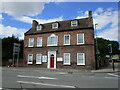
Montague House, Huntingdon
Mid eighteenth century house https://historicengland.org.uk/listing/the-list/list-entry/1128610 isolated from the town centre by the Ring Road which passes in front of it.
Image: © Jonathan Thacker
Taken: 10 Aug 2021
0.05 miles
7
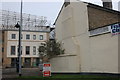
Walden Road at the junction of High Street Huntingdon
Hodsons fish and chips is on the right
Image: © David Howard
Taken: 12 Jan 2019
0.06 miles
8
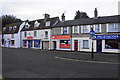
Essential Supermarket
The supermarket sells food in a numbers of styles from around the world. This is the northern end of High Street which was at one time the main route through the town. It is now very quiet with most traffic going round the ring road.
Image: © Bill Boaden
Taken: 10 Dec 2018
0.06 miles
9

Fish and Chip shop, Huntingdon
One of Huntingdon's best known landmarks. Easily accessed from the inner ring road so its convienent for passing traffic.
Image: © Michael Trolove
Taken: 18 Jul 2009
0.07 miles
10
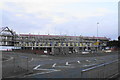
New development on Ferrars Road
I think this will be a care home.
Image: © Bill Boaden
Taken: 10 Dec 2018
0.08 miles