
IMAGES TAKEN NEAR TO
St. Anns Lane, HUNTINGDON, PE29 2EW
Introduction
This page details the photographs taken nearby to St. Anns Lane, PE29 2EW by members of the Geograph project.
The Geograph project started in 2005 with the aim of publishing, organising and preserving representative images for every square kilometre of Great Britain, Ireland and the Isle of Man.

There are currently over 7.5m images from over14,400 individuals and you can help contribute to the project by visiting https://www.geograph.org.uk
Image Map
Images are licensed for reuse under creativecommons.org/licenses/by-sa/2.0
Notes
- Clicking on the map will re-center to the selected point.
- The higher the marker number, the further away the image location is from the centre of the postcode.
Image Listing (284 Images Found)
Images are licensed for reuse under creativecommons.org/licenses/by-sa/2.0
Image
Details
Distance
1
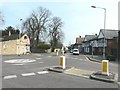
Roundabout in Godmanchester
Looking along Cambridge Street from its junction with Causeway
Image: © John Baker
Taken: 22 Mar 2012
0.01 miles
2

59, 60 and 62 Cambridge Street, Godmanchester
Early seventeenth century houses https://historicengland.org.uk/listing/the-list/list-entry/1310066
Image: © Jonathan Thacker
Taken: 10 Aug 2021
0.02 miles
3

59 to 62 Cambridge Street
The title refers to the range which includes the red tiled gable at the end nearest the camera. No 62 is dated 1611, and No.59 has the date 1613 in its chimney stack (not visible). Listed Grade II.
Image: © Alan Murray-Rust
Taken: 28 Dec 2012
0.04 miles
4

The Causeway looking towards Chadley Lane
Image: © David Howard
Taken: 22 Aug 2019
0.06 miles
5
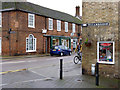
To Cambridge
The English Heritage listing implies that the signs are contemporary with the building which dates from around 1840. The building opposite is of late 18th century date and was once the coaching inn for Godmanchester. This probably accounts for the fine Venetian window, unusually placed here at ground floor. Listed Grade II.
Image: © Alan Murray-Rust
Taken: 28 Dec 2012
0.06 miles
6

Godmanchester, Cambs
Water running high and fast in November 2012
Image: © David Cumberland
Taken: Unknown
0.06 miles
7

To London
Early 19th century road sign on a shop http://www.geograph.org.uk/photo/605382 in Godmanchester
Image: © Richard Croft
Taken: 4 Nov 2007
0.06 miles
8

Shop with interesting signs
Shop with interesting direction signs Godmanchester Cambridgeshire. See http://www.geograph.org.uk/photo/822969 and http://www.geograph.org.uk/photo/822972 for photos of the signs.
Image: © Keith Evans
Taken: 28 May 2008
0.06 miles

10
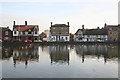
The Causeway
Historic property beside the River Ouse at Godmanchester
Image: © Richard Croft
Taken: 4 Nov 2007
0.06 miles