
IMAGES TAKEN NEAR TO
Carpenters Court, Rectory Lane, HUNTINGDON, PE28 3YZ
Introduction
This page details the photographs taken nearby to Carpenters Court, Rectory Lane, PE28 3YZ by members of the Geograph project.
The Geograph project started in 2005 with the aim of publishing, organising and preserving representative images for every square kilometre of Great Britain, Ireland and the Isle of Man.

There are currently over 7.5m images from over14,400 individuals and you can help contribute to the project by visiting https://www.geograph.org.uk
Image Map
Images are licensed for reuse under creativecommons.org/licenses/by-sa/2.0
Notes
- Clicking on the map will re-center to the selected point.
- The higher the marker number, the further away the image location is from the centre of the postcode.
Image Listing (69 Images Found)
Images are licensed for reuse under creativecommons.org/licenses/by-sa/2.0
Image
Details
Distance
1

Memorial plaque to eleven Somersham residents
Wellington X3811 of 156 Squadron was returning to Warboys after a raid over Germany.
Bad weather and severe icing is believed to have contributed to the tragedy which caused the crew to lose control of the aircraft. The crew all bailed out safely but the aircraft crashed onto a row of cottages narrowly missing Whitehall in Somersham Street.
Much more information can be found on this website https://masterbombercraig.wordpress.com/bomber-command-structure/no-8-pff-group-bomber-command/pathfinder-force-pff/raf-warboys-pff/
The aircrew were all killed on their next Operation.
Image: © Adrian S Pye
Taken: 21 Mar 2020
0.01 miles
2

Road junction in Somersham
A road junction towards the west of the village.
Image: © Peter Mackenzie
Taken: 29 Aug 2018
0.02 miles
3

High Street, Somersham
Looking toward the village.
Image: © Tim Marchant
Taken: 1 Aug 2010
0.03 miles
4

Whitehall, Somersham, now a school
In October 1942 a Wellington bomber X38111 crashed on a row of cottages next to Whitehall narrowly missing the building and killing eleven residents.
https://www.geograph.org.uk/photo/6420151
Image: © Adrian S Pye
Taken: 21 Mar 2020
0.03 miles
5
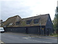
Somersham - Converted barn on the High Street
Image: © Richard Humphrey
Taken: 13 Oct 2015
0.04 miles
6

The old Tythe Barn, Somersham
I apologise for the photograph quality but it was unavoidably taken against direct sunlight.
On the side of the barn, which used to be thatched are three long poles with hooks which are to tear the thatch from the roof in the event of a fire.
"The Old Tithe Barn, a timber framed double aisled barn with weather boarded frontage and plain tile roof, dominates the street scene in the western end of the High Street. It was built around 1600 when the Bishop of Ely exchanged the manor and soke of Somersham for Crown properties. Once thatched, it still has the hooks on the exterior for removing the reed should it be in flames, despite it now being tiled.
A closer look of one of the hooks can be seen here https://www.geograph.org.uk/photo/6420163
Image: © Adrian S Pye
Taken: 21 Mar 2020
0.05 miles
7

One of the thatch hooks on Somersham Tythe Barn
https://www.geograph.org.uk/photo/6420159
Image: © Adrian S Pye
Taken: 21 Mar 2020
0.05 miles
8

Old dovecote
Situated in the churchyard Somersham. Said to date from late 18th or early 19th century. No longer in use.
http://www.britishlistedbuildings.co.uk/en-54167-dovecote-100-yards-to-the-rear-of-number-
Image: © Tony Bennett
Taken: 28 Dec 2008
0.06 miles
9

Pathfinder sign on the allotment gate post
One of the few legible signs as most have succumbed to the weather and are now blank discs. They do offer route reassurance despite having a map.
The annual full route walk details are available here http://www.73sqnwalkingclub.org.uk/pages/walk_details.htm
Image: © Michael Trolove
Taken: 18 May 2011
0.07 miles
10

Whitehall Close, Somersham
A quiet residential cul-de-sac in the village of Somersham.
Image: © Peter Mackenzie
Taken: 29 Aug 2018
0.08 miles