IMAGES TAKEN NEAR TO
Five Acre Field, St. Ives Road, HUNTINGDON, PE28 3DX
Introduction
This page details the photographs taken nearby to Five Acre Field, St. Ives Road, PE28 3DX by members of the Geograph project.
The Geograph project started in 2005 with the aim of publishing, organising and preserving representative images for every square kilometre of Great Britain, Ireland and the Isle of Man.

There are currently over 7.5m images from over14,400 individuals and you can help contribute to the project by visiting https://www.geograph.org.uk
Image Map
Images are licensed for reuse under creativecommons.org/licenses/by-sa/2.0
Notes
- Clicking on the map will re-center to the selected point.
- The higher the marker number, the further away the image location is from the centre of the postcode.
Image Listing (2 Images Found)
Images are licensed for reuse under creativecommons.org/licenses/by-sa/2.0
Image
Details
Distance
1
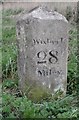
Old Milestone by the B1040, St Ives Road, Somersham parish
Carved stone post by the B1040, in parish of SOMERSHAM (HUNTINGDONSHIRE District), St Ives Road, Southeast of Rectory Farm (Mushroom Farm), Pidley, on the verge, on East side of road. St Ives stone, erected by the Somersham turnpike trust in the 19th century.
Inscription reads:-
: St. Ives / 3 / Miles : : Somersham / Parish : : Wisbech / 28 / Miles :
Grade II listed.
List Entry Number: 1128395 https://historicengland.org.uk/listing/the-list/list-entry/1128395
Milestone Society National ID: HU_SIWB03.
Image: © MW Hallett
Taken: 31 Dec 2002
0.14 miles
2
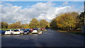
The Raptor Foundation
The spacious car park at the Raptor Foundation viewed in lovely autumn sunshine.
Image: © Peter Mackenzie
Taken: 11 Nov 2017
0.14 miles