IMAGES TAKEN NEAR TO
Collinson Crescent, HUNTINGDON, PE28 2GB
Introduction
This page details the photographs taken nearby to Collinson Crescent, PE28 2GB by members of the Geograph project.
The Geograph project started in 2005 with the aim of publishing, organising and preserving representative images for every square kilometre of Great Britain, Ireland and the Isle of Man.

There are currently over 7.5m images from over14,400 individuals and you can help contribute to the project by visiting https://www.geograph.org.uk
Image Map
Images are licensed for reuse under creativecommons.org/licenses/by-sa/2.0
Notes
- Clicking on the map will re-center to the selected point.
- The higher the marker number, the further away the image location is from the centre of the postcode.
Image Listing (8 Images Found)
Images are licensed for reuse under creativecommons.org/licenses/by-sa/2.0
Image
Details
Distance
3
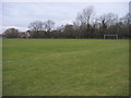
Football pitches
Football pitches Sapley Park
Image: © Shaun Ferguson
Taken: 7 Feb 2013
0.17 miles
4
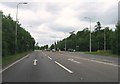
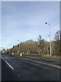
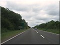
Spittals Way at the junction of Kings Ripton Road, Hartford
This is the Huntingdon bypass.
Image: © David Howard
Taken: 14 Aug 2022
0.17 miles
7
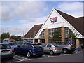
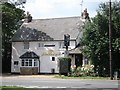
Tesco at Huntingdon
The Tesco Extra at Sapley in Huntingdon.
Image: © Martin Speck
Taken: 10 Oct 2011
0.21 miles
8
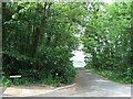
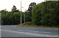
Entrance to Sapley Park Farms, Huntingdon
Image: © Richard Humphrey
Taken: 25 May 2010
0.21 miles