
IMAGES TAKEN NEAR TO
Vale Court, Vale Road Industrial Estate, SPILSBY, PE23 5HF
Introduction
This page details the photographs taken nearby to Vale Court, Vale Road Industrial Estate, PE23 5HF by members of the Geograph project.
The Geograph project started in 2005 with the aim of publishing, organising and preserving representative images for every square kilometre of Great Britain, Ireland and the Isle of Man.

There are currently over 7.5m images from over14,400 individuals and you can help contribute to the project by visiting https://www.geograph.org.uk
Image Map
Images are licensed for reuse under creativecommons.org/licenses/by-sa/2.0
Notes
- Clicking on the map will re-center to the selected point.
- The higher the marker number, the further away the image location is from the centre of the postcode.
Image Listing (45 Images Found)
Images are licensed for reuse under creativecommons.org/licenses/by-sa/2.0
Image
Details
Distance
1

Railway Station (former), Spilsby
This is the site of the former Spilsby Station and goods yard, on Boston Road, which closed for passengers at the beginning of WWII in 1939. Freight traffic continued though in decline. An upsurge in 1956 was the result of incoming cement products for the aerodrome expansion at East Kirkby, but in 1957 concerns were raised about the state of the railway bridge over the Steeping River. Estimates for a replacement were £20,000, so the railway succumbed to closure and the last locomotive left the branch line on 30th November 1958. The link to the Great Northern Railway closed the following day.
The site is now occupied by Chandlers (Farm Equipment) Ltd.
Image: © Dave Hitchborne
Taken: 26 Jan 2008
0.17 miles
2

Railway Station (former), Spilsby
Boston Road - The site of the former Spilsby Station and goods yard, which closed for passengers at the beginning of WWII in 1939. Freight traffic continued though in decline. An upsurge in 1956 was the result of incoming cement products for the aerodrome expansion at East Kirkby, but in 1957 concerns were raised about the state of the railway bridge over the Steeping River. Estimates for a replacement were £20,000, so the railway succumbed to closure and the last locomotive left the branch line on 30th November 1958. The link to the Great Northern Railway closed the following day.
The site is now occupied by Chandlers (Farm Equipment) Ltd.
Image: © Dave Hitchborne
Taken: 26 Jan 2008
0.17 miles
3

Boston Road, Spilsby
The site of the former Spilsby Station and goods yard, which closed for passengers at the beginning of WWII in 1939. Freight traffic continued though in decline. An upsurge in 1956 was the result of incoming cement products for the aerodrome expansion at East Kirkby, but in 1957 concerns were raised about the state of the railway bridge over the Steeping River. Estimates for a replacement were £20,000, so the railway succumbed to closure and the last locomotive left the branch line on 30th November 1958. The link to the Great Northern Railway closed the following day.
The site is now occupied by Chandlers (Farm Equipment) Ltd.
I presume that the building is an old goods shed with a later addition.
Image: © Dave Hitchborne
Taken: 26 Jan 2008
0.17 miles
4

Avenue Terrace, Spilsby
I took this shot too close to the houses. It gives the impression that they have a flat roof, when in fact they have hipped roofs. They stand right next door to Chandlers and the old railway yard. The railway ceased on 30th November 1958. http://www.geograph.org.uk/photo/697203
Image: © Dave Hitchborne
Taken: 26 Jan 2008
0.18 miles
5

Avenue Terrace, Spilsby
The old enamel street nameplate.
Image: © Dave Hitchborne
Taken: 26 Jan 2008
0.18 miles
6

Halton Road, Spilsby
Another view of the Town Hall. http://www.geograph.org.uk/photo/696187 The walkway, to the right of the building, leads to more housing and to the Industrial Estate.
Image: © Dave Hitchborne
Taken: 26 Jan 2008
0.19 miles
7

Boston Road, Spilsby
The road to the left is Vale Road, which leads to further housing and the Industrial Estate. The buildings on the industrial estate occupy former railway land and those opposite stand on the site of the former Spilsby Station and goods yard, which closed for passengers at the beginning of WWII in 1939. Freight traffic continued though in decline.
An upsurge in 1956 was the result of incoming cement products for the aerodrome expansion at East Kirkby, but in 1957 concerns were raised about the state of the railway bridge over the Steeping River. Estimates for a replacement were £20,000, so the railway succumbed to closure and the last locomotive left the branch line on 30th November 1958. The link to the Great Northern Railway closed the following day.
Image: © Dave Hitchborne
Taken: 26 Jan 2008
0.20 miles
8

Vale Road Industrial Estate, Spilsby
An industrial estate at the junction of Boston Road and Vale Road.
Image: © David P Howard
Taken: 6 Mar 2015
0.20 miles
9
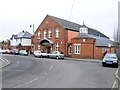
Halton Road, Spilsby
Franklin Hall, the Town Clerk's Office. Office Hours are: - Mon, Wed, Thur from 10.00am - 3.00pm. Monthly meetings are: - The fourth Thursday in the month at 7.15pm.
Halton Road, seen here heading left, goes on to Wainfleet and the coast.
Image: © Dave Hitchborne
Taken: 26 Jan 2008
0.20 miles
10

Forest of crosses, Spilsby cemetery
Image: © Jonathan Thacker
Taken: 14 Jul 2022
0.20 miles