
IMAGES TAKEN NEAR TO
Spilsby Road, BOSTON, PE22 8LE
Introduction
This page details the photographs taken nearby to Spilsby Road, PE22 8LE by members of the Geograph project.
The Geograph project started in 2005 with the aim of publishing, organising and preserving representative images for every square kilometre of Great Britain, Ireland and the Isle of Man.

There are currently over 7.5m images from over14,400 individuals and you can help contribute to the project by visiting https://www.geograph.org.uk
Image Map
Images are licensed for reuse under creativecommons.org/licenses/by-sa/2.0
Notes
- Clicking on the map will re-center to the selected point.
- The higher the marker number, the further away the image location is from the centre of the postcode.
Image Listing (14 Images Found)
Images are licensed for reuse under creativecommons.org/licenses/by-sa/2.0
Image
Details
Distance


3

Soilmarks on field between Thorpe Drain and Bell Water Drain: aerial 2025
North of New Leake.
Image: © Simon Tomson
Taken: 30 Apr 2025
0.17 miles
4
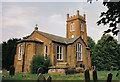
Eastville parish church, Lincs
– built in 1840 in near isolation 1½ miles north of the village and dedicated to St Paul.
Image: © Rodney Burton
Taken: Unknown
0.20 miles
5

The Vicarage
The vicarage stands just across the lane from the church.
Image: © Dave Hitchborne
Taken: 26 May 2007
0.21 miles
6

Stages in the demolition of the Church of St Paul, Eastville
See Image which shows the church only 3 days later, and tells the sad story of its condemnation.
Its guardian angel, bottom left, seems to have been powerless to save it.
Image: © Chris
Taken: 7 Jun 2015
0.23 miles
7
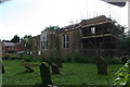
Stages in the demolition of the Church of St Paul, Eastville
See Image which shows the church only 3 days later, and tells the sad story of its condemnation.
Image: © Chris
Taken: 7 Jun 2015
0.23 miles
8
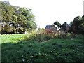
The site of St. Paul's church
The church Image was demolished in 2015 Image Now the site is marked by a tangle of vegetation with the outline of the church laid out in stone.
Image: © Jonathan Thacker
Taken: 8 Sep 2019
0.23 miles
9

The Church of St Paul, Eastville
After being digitally monitored for two years, it was seen that the church had become structurally unsound and that the problem was worsening. The south facing chancel is parting from the nave and both the west and east walls are slowly leaning more and more out of true and to compound this much of the timber is rotten and riddled with woodworm, as can be seen. Sadly, it is now being demolished brick-by-brick.
The church was closed back in 2007, after 146 years of worship.
When the site has been cleared, the footprint of the church will be marked with paving, gravestones re-positioned and the font buried.
There is no access to the site.
Image: © Dave Hitchborne
Taken: 10 Jun 2015
0.23 miles
10
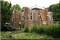
The Church of St Paul, Eastville
After being digitally monitored for two years, it was seen that the church had become structurally unsound and that the problem was worsening. The south facing chancel is parting from the nave and both the west and east walls are slowly leaning more and more out of true and to compound this much of the timber is rotten and riddled with woodworm. Sadly, it is now being demolished brick-by-brick.
The church was closed back in 2007, after 146 years of worship.
When the site has been cleared, the footprint of the church will be marked with paving, gravestones re-positioned and the font buried.
There is no access to the site.
Three days earlier - http://www.geograph.org.uk/photo/4529111
Image: © Dave Hitchborne
Taken: 10 Jun 2015
0.24 miles