
IMAGES TAKEN NEAR TO
Allington Garden, BOSTON, PE21 9DP
Introduction
This page details the photographs taken nearby to Allington Garden, PE21 9DP by members of the Geograph project.
The Geograph project started in 2005 with the aim of publishing, organising and preserving representative images for every square kilometre of Great Britain, Ireland and the Isle of Man.

There are currently over 7.5m images from over14,400 individuals and you can help contribute to the project by visiting https://www.geograph.org.uk
Image Map
Images are licensed for reuse under creativecommons.org/licenses/by-sa/2.0
Notes
- Clicking on the map will re-center to the selected point.
- The higher the marker number, the further away the image location is from the centre of the postcode.
Image Listing (101 Images Found)
Images are licensed for reuse under creativecommons.org/licenses/by-sa/2.0
Image
Details
Distance
1
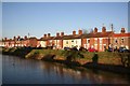
Willoughby Road
Houses on the sunny side of Maud Foster Drain
Image: © Richard Croft
Taken: 30 Jan 2008
0.11 miles
3

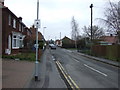
Willoughby Road
Maud Foster Drain and Willoughby Road looking north from Hospital Bridge http://www.geograph.org.uk/photo/679856
Image: © Richard Croft
Taken: 30 Jan 2008
0.13 miles
4

Willoughby Road Almshouses
Victorian Almshouses seen from Horncastle Road
Image: © Richard Croft
Taken: 30 Jan 2008
0.14 miles
5

The Maud Foster Drain north of the Hospital Footbridge
At the end of the brick retaining wall the pond weed or algae on the surface of the water suddenly end where there appears to be a cord across the drain.
Image: © Humphrey Bolton
Taken: 11 Sep 2021
0.14 miles
6

Cast iron bridge, Boston
Made 1811 in Butterley, presumably by the famous Butterley Iron Company. This is an early survivor and a very flat arch too. Used as a foot bridge only.
Image: © Chris Allen
Taken: 6 Oct 2007
0.14 miles
7

Willoughby Road Almshouses
Successors to St.Leonard's Hospital, the old tenements were pulled down and rebuilt by the benefaction of local solicitor B.S.Simpson and bank director J.R.Rawson in the 1860s and 70s. The two end pairs of semi-detached cottages have datestones with 'BSS 1869' and 'JRR 1873' with a row of six cottages between with 'In Memoriam 1874'
Image: © Richard Croft
Taken: 30 Jan 2008
0.15 miles
8

Willoughby Road
Looking north along Maud Foster Drain with houses on Willoughby Road
Image: © Richard Croft
Taken: 30 Jan 2008
0.15 miles
9

Hospital Bridge
One of three footbridges cast at Butterley in Derbyshire in 1811 and erected over the Maud Foster Drain. Designed either by John Rennie or William Jessop, Vauxhall Bridge was replaced by a road bridge in 1924 but Cowbridge http://www.geograph.org.uk/photo/674590 also remains
Image: © Richard Croft
Taken: 6 Feb 2008
0.15 miles
10
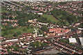
The Maud Foster Windmill and Drain
Looking ESE across the northern part of Boston.
Image: © Chris
Taken: 13 Jun 2013
0.15 miles