
IMAGES TAKEN NEAR TO
Carlton Road, BOSTON, PE21 8NP
Introduction
This page details the photographs taken nearby to Carlton Road, PE21 8NP by members of the Geograph project.
The Geograph project started in 2005 with the aim of publishing, organising and preserving representative images for every square kilometre of Great Britain, Ireland and the Isle of Man.

There are currently over 7.5m images from over14,400 individuals and you can help contribute to the project by visiting https://www.geograph.org.uk
Image Map
Images are licensed for reuse under creativecommons.org/licenses/by-sa/2.0
Notes
- Clicking on the map will re-center to the selected point.
- The higher the marker number, the further away the image location is from the centre of the postcode.
Image Listing (91 Images Found)
Images are licensed for reuse under creativecommons.org/licenses/by-sa/2.0
Image
Details
Distance
1
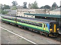
Railway Station, Boston
The term Railway Station seems to have fallen out of favour and is now referred to as Train Station. Is this another 'Americanism' I wonder?
The Central Trains 2-car-unit is Class 156407.
Image: © Dave Hitchborne
Taken: 26 Sep 2003
0.08 miles
2

5 Sleaford Road, Boston
Early 19th century house (c.1830), which has now become isolated in the middle of a road junction. Currently occupied by the Skegness College of Vocational Training, with the name Freiston Lodge. Listed Grade II.
Image: © Alan Murray-Rust
Taken: 19 Nov 2014
0.10 miles
3

Railway Station, Boston
Restricted access to the crossing control electrics.
Image: © Dave Hitchborne
Taken: 3 Dec 2012
0.11 miles
4

ASDA Sign
Viewed from the station footbridge.
Image: © John Lucas
Taken: 27 Nov 2008
0.11 miles
5

Railway Station, Boston
A view from the Down platform shows a crossover from the Up-line to the Down-line. Trains from Skegness terminating at Boston can cross over and do a return trip back to the coastal town. In spite of the dark clouds the weather was changing for the better.
Image: © Dave Hitchborne
Taken: 3 Dec 2012
0.11 miles
6

Railway Station, Boston
View of the Down line from the station footbridge. The significance of Down and Up is that Down is from London and Up is to London.
Image: © Dave Hitchborne
Taken: 3 Dec 2012
0.11 miles
7
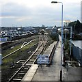
Railway Station, Boston
The ramped end of the Down platform leads to a path that runs to Sleaford Road and provides disabled access to the station and trains to Skegness.
Image: © Dave Hitchborne
Taken: 3 Dec 2012
0.11 miles
8

Boston Stump view - W
View across Boston from the Stump with Asda superstore now a prominent feature
Image: © Richard Croft
Taken: 18 Sep 2008
0.11 miles
9

Railway Station, Boston
Platform 2 illuminated announcement board, which is currently announcing the 12:19 Skegness, at 11:55:20
Image: © Dave Hitchborne
Taken: 3 Dec 2012
0.11 miles
10

Southward from Boston Station
View southward, towards Sleaford, Spalding and Peterborough; ex-Great Northern Lincolnshire Loop Line. On the left is the Summer Saturday 12.48 Mablethorpe - Derby Friargate express, with B1 4-6-0 No. 61299; its fireman is standing on the tender as it is filled up with water. The train will turn right shortly to Sleaford, thence Grantham, Nottingham and Derby. Most of the trains here were already Diesel-hauled and most of the Loop was closed in 1970.
Image: © Ben Brooksbank
Taken: 25 Jul 1964
0.11 miles