
IMAGES TAKEN NEAR TO
Pen Street, BOSTON, PE21 6TF
Introduction
This page details the photographs taken nearby to Pen Street, PE21 6TF by members of the Geograph project.
The Geograph project started in 2005 with the aim of publishing, organising and preserving representative images for every square kilometre of Great Britain, Ireland and the Isle of Man.

There are currently over 7.5m images from over14,400 individuals and you can help contribute to the project by visiting https://www.geograph.org.uk
Image Map
Images are licensed for reuse under creativecommons.org/licenses/by-sa/2.0
Notes
- Clicking on the map will re-center to the selected point.
- The higher the marker number, the further away the image location is from the centre of the postcode.
Image Listing (308 Images Found)
Images are licensed for reuse under creativecommons.org/licenses/by-sa/2.0
Image
Details
Distance

2
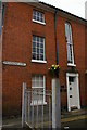
Boston: house on Threadneedle Street
The two upper windows on the left side of the building are fakes, presumably to give a harmonious appearance whilst avoiding the 18th century window tax.
Image: © Christopher Hilton
Taken: 17 Aug 2013
0.03 miles

4

Artillery Row, Boston, Lincs PE21 6TY
This short section of street cut off by the John Adams Way inner relief road contains a number of commercial premises, a snooker hall, betting shop, fast food and takeaway shop, double glazing and window installers, wallpaper shop, mobile phone shop and a hairdresser's shop on the corner of Main Ridge.
Image: © Rodney Burton
Taken: 28 Apr 2007
0.06 miles
5

Main Ridge East, Boston
BOSTON CENTRAL RACING PIG CLUB. They've been racing a PIG here for EONS.
Image: © Dave Hitchborne
Taken: 12 Dec 2012
0.06 miles
6
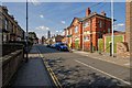
Main Ridge West, Boston
The building to the right is the Army Careers office. I was going to sign up, but they were shut.
Image: © Dave Hitchborne
Taken: 27 Sep 2013
0.06 miles
7

Field Street, Boston
Beyond the fence is John Adams Way, a dual-carriageway. In the distance is the tower of St Botolph "The Stump".
Image: © Dave Hitchborne
Taken: 15 Apr 2008
0.08 miles
8
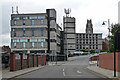
Telephone exchange, Boston
Guessing this dates from the 1970s, and even though it's not very tall it seems a little out of scale with the rest of the town. Probably only the Stump - on the right - is taller (but I've not done a proper survey).
Image: © Stephen Richards
Taken: Unknown
0.08 miles
9
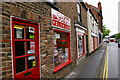
Boston: Sezam Polish shop on Pen Street
An indication of the greater movement of populations between this country and Eastern Europe since the end of the Cold War (and particularly of the great movement of Eastern Europeans in search of work to the agricultural industries of the Fenlands).
Image: © Christopher Hilton
Taken: 17 Aug 2013
0.08 miles
10
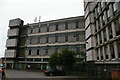
Boston: closed British Telecom building
Image: © Christopher Hilton
Taken: 17 Aug 2013
0.08 miles