
IMAGES TAKEN NEAR TO
The Dock, BOSTON, PE21 6BJ
Introduction
This page details the photographs taken nearby to The Dock, PE21 6BJ by members of the Geograph project.
The Geograph project started in 2005 with the aim of publishing, organising and preserving representative images for every square kilometre of Great Britain, Ireland and the Isle of Man.

There are currently over 7.5m images from over14,400 individuals and you can help contribute to the project by visiting https://www.geograph.org.uk
Image Map
Images are licensed for reuse under creativecommons.org/licenses/by-sa/2.0
Notes
- Clicking on the map will re-center to the selected point.
- The higher the marker number, the further away the image location is from the centre of the postcode.
Image Listing (64 Images Found)
Images are licensed for reuse under creativecommons.org/licenses/by-sa/2.0
Image
Details
Distance
1
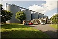
Skirbeck Road, Boston
Grain silos dwarf the former gatehouse to the workhouse. It was built by Sir Gilbert Scott in 1837. The workhouse closed in the 1970s and most of the buildings were demolished in 1978. The gatehouse steadily fell into ruin until Heritage Lincolnshire restored and repaired the structure in 2001. The building, renamed Scott House is now owned by Lincolnshire County Council and operates as a resource centre for adults with physical disabilities.
Image: © Dave Hitchborne
Taken: 26 Sep 2013
0.05 miles
2

Bench Mark on Scott House
This must have been a popular route for OS surveyors because there are quite a few to be seen along this, the Skirbeck road.
Image: © Michael Trolove
Taken: 9 Apr 2010
0.06 miles
3

Former St. John's Workhouse, Boston
This building must have one of the strangest backdrops in Boston - huge grain silos. This is the Gatehouse to the former Workhouse and was built by Sir Gilbert Scott in 1837. The Workhouse closed in the 1970s and most of the buildings were demolished in 1978. The Gatehouse steadily fell into ruin until Heritage Lincolnshire restored and repaired the structure in 2001. The building, renamed Scott House is now owned by Lincolnshire County Council and operates as a resource centre for adults with physical disabilities.
Image: © Dave Hitchborne
Taken: 11 Sep 2007
0.06 miles
4

Recycling at Boston Docks
Discarded metal objects such as convector heaters (top right) destined to be melted down. See Image
Image: © paul dickson
Taken: 23 Mar 2008
0.06 miles
5

Scott House
Grade II listed former entrance to the Union Workhouse, by Sir George Gilbert Scott 1837. The Workhouse had dormitories and accommodation for up to 450 people but closed by the early 20th century. After several incarnations as HMS Arabella Royal Navy Training, a school and latterly a mortuary, the workhouse buildings were demolished in 1980 and replaced by grain silos.
This marvellous entrance range survives as Council offices.
Image: © Richard Croft
Taken: 2 Aug 2022
0.06 miles
6

Silos, Boston
By the docks at the end of St John's Road. According to the port's website Boston has 8,000 tonnes of grain silos.
Image: © Stephen Richards
Taken: Unknown
0.07 miles

8

Scott House
A Lincolnshire Social Services office and a British Red Cross facility dominated by the grain storage silos of Openfields on Boston dock.
Image: © Michael Trolove
Taken: 9 Apr 2010
0.08 miles
9
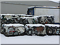
Boston Dockyard
Blocks of "metal rubbish" ready to be shipped for recycling, topped with snow.
A container vessel can be seen behind right and behind that one of the large metal sheds by the docks. I assume that I've got this the right way around and these haven't been imported!
Image: © paul dickson
Taken: 23 Mar 2008
0.08 miles
10

Georgian semis
A pair of Grade II listed late 18th century houses on Skirbeck Road, now ignominiously vandalised and semi-derelict
Image: © Richard Croft
Taken: 9 Feb 2009
0.08 miles