
IMAGES TAKEN NEAR TO
Greenacre Close, BOSTON, PE20 2HE
Introduction
This page details the photographs taken nearby to Greenacre Close, PE20 2HE by members of the Geograph project.
The Geograph project started in 2005 with the aim of publishing, organising and preserving representative images for every square kilometre of Great Britain, Ireland and the Isle of Man.

There are currently over 7.5m images from over14,400 individuals and you can help contribute to the project by visiting https://www.geograph.org.uk
Image Map
Images are licensed for reuse under creativecommons.org/licenses/by-sa/2.0
Notes
- Clicking on the map will re-center to the selected point.
- The higher the marker number, the further away the image location is from the centre of the postcode.
Image Listing (11 Images Found)
Images are licensed for reuse under creativecommons.org/licenses/by-sa/2.0
Image
Details
Distance
1
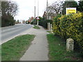
To Boston 6
Old milestone on the B1397 Sutterton, Lincolnshire. For close up view see http://www.geograph.org.uk/photo/1186362 For more info about the stone see http://milestones.megalithia.com/sites/tf286359.htm and do have a look at their home page.
Image: © Keith Evans
Taken: 2 Mar 2009
0.07 miles
2
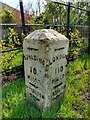
Old Milestone by B1397, Boston Road, outside The Rylands (South of Tudor Lodge)
The Milestone is located on the verge on the East of the road. Parish of Sutterton (Boston District). Carved stone post, design, erected by the Donington turnpike trust in the 19th Century. An earlier photograph can be found here: https://www.geograph.org.uk/photo/6126414
Inscription reads:-
LONDON / 110 / MILES / SUTTERTON : : SPALDING / 10 / MILES / SUTTERTON : : BOSTON / 6 / MILES / SUTTERTON
Grade II listed. List Entry Number: 1062033 https://historicengland.org.uk/listing/the-list/list-entry/1062033
Milestone Society National ID: LI_SPBO10
Image: © Hilary Jones
Taken: 15 Apr 2023
0.08 miles
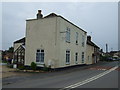
4
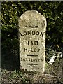
Old Milestone by the B1397, Boston Road, Sutterton
Milestone by the B1397, in parish of Sutterton (Boston District), Boston Road, outside The Rylands (South of Tudor Lodge), on the verge.
Inscription reads:-
-----
LONDON
110
MILES
-----
SUTTERTON
-----
Grade II listed.
List Entry Number: 1062033 https://historicengland.org.uk/listing/the-list/list-entry/1062033
Milestone Society National ID: LI_SPBO10
Image: © Milestone Society
Taken: Unknown
0.09 miles

6
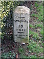
Old Milestone
Old milestone on the B1397 Sutterton, Lincolnshire. For overall view see http://www.geograph.org.uk/photo/1186365 For more info on the stone see http://milestones.megalithia.com/sites/tf286359.htm and do have a look at their home page.
Image: © Keith Evans
Taken: 2 Mar 2009
0.10 miles
10

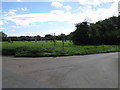
Bell Mere Pool
Conservation area around Bell Mere Pool, possibly a Romano-British clay pit, possibly a Medieval salt-pan but certainly a pool of great antiquity in Sutterton
Image: © Richard Croft
Taken: 8 Aug 2009
0.23 miles