
IMAGES TAKEN NEAR TO
The Crescent, ST. NEOTS, PE19 8HF
Introduction
This page details the photographs taken nearby to The Crescent, PE19 8HF by members of the Geograph project.
The Geograph project started in 2005 with the aim of publishing, organising and preserving representative images for every square kilometre of Great Britain, Ireland and the Isle of Man.

There are currently over 7.5m images from over14,400 individuals and you can help contribute to the project by visiting https://www.geograph.org.uk
Image Map
Images are licensed for reuse under creativecommons.org/licenses/by-sa/2.0
Notes
- Clicking on the map will re-center to the selected point.
- The higher the marker number, the further away the image location is from the centre of the postcode.
Image Listing (23 Images Found)
Images are licensed for reuse under creativecommons.org/licenses/by-sa/2.0
Image
Details
Distance
1
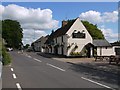
The 'Waggon & Horses', Great North Road, Eaton Socon
View north, along what was for centuries the main route linking London with Scotland and the north of England. The Waggon & Horses is one of a good many pubs along this stretch. Not far behind the camera there's the Old Sun, and then (further south) the Wheatsheaf. No doubt most started out as coaching inns, making a good living from 'passing trade'. The settlement pattern here must have amounted to an early form of ribbon-development.
In any case, it's good to see that so many of these old road-houses survive in 21st century conditions
Image: © Stefan Czapski
Taken: 24 May 2016
0.09 miles
2

Footpath to Peppercorns Lane, Eaton Socon
From St Mary's Churchyard
Image: © Rich Tea
Taken: 20 Jun 2009
0.15 miles

5

St.Mary's church
Decorated and Perpendicular church, gutted by fire in 1930 and rebuilt by Sir Albert Richardson
Image: © Richard Croft
Taken: 29 Jan 2009
0.18 miles
6

Parish church, Eaton Socon, Hunts/Cambs
The church of St Mary the Virgin originally built in the beginning of the 15th century, burned down 8 Feb 1930, but it was immediately rebuilt and consecrated in 1932.
Image: © Rodney Burton
Taken: 24 Jan 2007
0.18 miles
7

St.Mary's church
Rebuilt after a disastrous fire in 1930
Image: © Richard Croft
Taken: 29 Jan 2009
0.18 miles
8

The tower of St Mary's Church, Eaton Socon
Image: © Rich Tea
Taken: 20 Jun 2009
0.19 miles
9

Footpath, St Mary's Churchyard, Eaton Socon
The footpath crosses the back of the churchyard from Peppercorns Lane to School Lane.
Image: © Rich Tea
Taken: 20 Jun 2009
0.19 miles
10

St Mary's Church, Eaton Socon
The south side, and the base of the tower Image]
Image: © Rich Tea
Taken: 20 Jun 2009
0.19 miles