
IMAGES TAKEN NEAR TO
Hooper Crescent, ST. NEOTS, PE19 6BZ
Introduction
This page details the photographs taken nearby to Hooper Crescent, PE19 6BZ by members of the Geograph project.
The Geograph project started in 2005 with the aim of publishing, organising and preserving representative images for every square kilometre of Great Britain, Ireland and the Isle of Man.

There are currently over 7.5m images from over14,400 individuals and you can help contribute to the project by visiting https://www.geograph.org.uk
Image Map
Images are licensed for reuse under creativecommons.org/licenses/by-sa/2.0
Notes
- Clicking on the map will re-center to the selected point.
- The higher the marker number, the further away the image location is from the centre of the postcode.
Image Listing (80 Images Found)
Images are licensed for reuse under creativecommons.org/licenses/by-sa/2.0
Image
Details
Distance
1
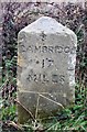
Old Milestone by the B1428, Cambridge Road, St Neots
Carved stone post by the B1428, in parish of St Neots Rural (Huntingdonshire District), Cambridge Road, by Rowley Park Football Ground, on grass verge, on North side of road. St Neot stone, erected by the St Neots to Cambridge turnpike trust in the 19th century.
Inscription reads:-
: CAMBRIDGE / 17 / MILES : : ST NEOTS / 1 MILE :
Grade II listed.
List Entry Number: 1290057 https://historicengland.org.uk/listing/the-list/list-entry/1290057
Milestone Society National ID: HU_CASN17
Image: © MW Hallett
Taken: Unknown
0.04 miles
2
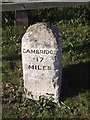
Old Milepost
Old milepost on what was the A45 at St. Neots, Cambridgeshire. For overall view see http://www.geograph.org.uk/photo/2581919
Image: © Keith Evans
Taken: 1 Sep 2011
0.04 miles
3
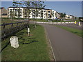
To St. Neots 1
Old milestone on what was the A45 at St. Neots, Cambridgeshire. For close up view see http://www.geograph.org.uk/photo/2581912
Image: © Keith Evans
Taken: 1 Sep 2011
0.04 miles
4
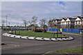
Roundabout
A roundabout on Cambridge Road, the B1428.
Image: © Bob Harvey
Taken: 7 Dec 2022
0.05 miles
5

The bridge
The bridge over the Fox Brook. I did consider photographing the waterway itself, but it is a tangle of willows right up to the bridge so nothing is visible.
Image: © Bob Harvey
Taken: 7 Dec 2022
0.05 miles
6

Gorham Way
Modern housing estates have far too little provision for visitor parking.
Image: © Bob Harvey
Taken: 7 Dec 2022
0.06 miles
7

Built on a curve
A terrace block with a curious windowless frontage where the fourth floor might be.
Image: © Bob Harvey
Taken: 7 Dec 2022
0.06 miles
8
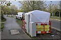
All secure
A weatherproof cover erected around a telecoms termination box.
Image: © Bob Harvey
Taken: 7 Dec 2022
0.07 miles
9

The Fox Brook
A stream, and a couple of pools, break up the Loves Farm estate.
Image: © Bob Harvey
Taken: 7 Dec 2022
0.07 miles
10
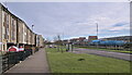
Loves Way
Loves Way is the name of this bus stop, taken from the small road a little further along. Love's Farm is the name of a recent development in the erstwhile open fields next to St Neot's station, bounded at its southern edge by this, the B1428 Cambridge Road.
Image: © Bob Harvey
Taken: 7 Dec 2022
0.09 miles