
IMAGES TAKEN NEAR TO
Loves Way, ST. NEOTS, PE19 6AX
Introduction
This page details the photographs taken nearby to Loves Way, PE19 6AX by members of the Geograph project.
The Geograph project started in 2005 with the aim of publishing, organising and preserving representative images for every square kilometre of Great Britain, Ireland and the Isle of Man.

There are currently over 7.5m images from over14,400 individuals and you can help contribute to the project by visiting https://www.geograph.org.uk
Image Map
Images are licensed for reuse under creativecommons.org/licenses/by-sa/2.0
Notes
- Clicking on the map will re-center to the selected point.
- The higher the marker number, the further away the image location is from the centre of the postcode.
Image Listing (41 Images Found)
Images are licensed for reuse under creativecommons.org/licenses/by-sa/2.0
Image
Details
Distance
1

Belland Hill
New housing on the outskirts of St Neots - off Cambridge Road.
Image: © JThomas
Taken: 4 Jun 2015
0.02 miles
2

Sales Office and Housing
One of many Sales Offices and housing on Loves Farm Estate.
Image: © John Webber
Taken: 13 Aug 2009
0.06 miles
3
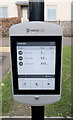
Electronic timetable
This is the departure board on the bus stop stanchion in Image It has an eInk paper-white display, which is an excellent use for this display technology - it consumes no power at all between refreshes and can be read in bright daylight. At night it can be internally illuminated. This is the first bus stop I have seen so equipped, and it is an excellent idea.
Image: © Bob Harvey
Taken: 7 Dec 2022
0.07 miles
4
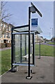
Bus stop with two names
This is the bus stop seen in Image, and named on timetables and maps as "Loves Lane". The bus stop flag says "Loves Farm", which is the name of the housing estate to the North.
The bus stop is equipped with an electronic timetable and illumination powered by the solar panel on the top of the pole. The glass panel at this end of the bus stop is a rollerblind animated advertisement housing, with no advertisements.
Image: © Bob Harvey
Taken: 7 Dec 2022
0.08 miles
5
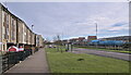
Loves Way
Loves Way is the name of this bus stop, taken from the small road a little further along. Love's Farm is the name of a recent development in the erstwhile open fields next to St Neot's station, bounded at its southern edge by this, the B1428 Cambridge Road.
Image: © Bob Harvey
Taken: 7 Dec 2022
0.08 miles
6

Loves Farm Development
The main residential frontage to Loves Farm Estate.
Image: © John Webber
Taken: 13 Aug 2009
0.08 miles
7
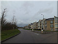
B1428 Cambridge Road, St.Neots
At the Loves Farm roundabout
Image: © Geographer
Taken: 16 Dec 2013
0.09 miles
8

Footpath alongside Fox Brook, St Neots
Actually, between Fox Brook and Fox Brook: the road on the right is named Fox Brook after the stream hidden behind the trees to the left.
Image: © Richard Vince
Taken: 14 Jan 2023
0.09 miles
9

Fox Brook, St Neots
Full and muddy on a wet January day.
Image: © Richard Vince
Taken: 14 Jan 2023
0.10 miles
10

Gorham Way
Modern housing estates have far too little provision for visitor parking.
Image: © Bob Harvey
Taken: 7 Dec 2022
0.10 miles