
IMAGES TAKEN NEAR TO
St. Hughs Road, ST. NEOTS, PE19 5UB
Introduction
This page details the photographs taken nearby to St. Hughs Road, PE19 5UB by members of the Geograph project.
The Geograph project started in 2005 with the aim of publishing, organising and preserving representative images for every square kilometre of Great Britain, Ireland and the Isle of Man.

There are currently over 7.5m images from over14,400 individuals and you can help contribute to the project by visiting https://www.geograph.org.uk
Image Map
Images are licensed for reuse under creativecommons.org/licenses/by-sa/2.0
Notes
- Clicking on the map will re-center to the selected point.
- The higher the marker number, the further away the image location is from the centre of the postcode.
Image Listing (129 Images Found)
Images are licensed for reuse under creativecommons.org/licenses/by-sa/2.0
Image
Details
Distance
1

Pedestrian Subway
The Buckden/Hardwick underpass from the Buckden side.
Image: © Michael Trolove
Taken: 28 Feb 2009
0.09 miles

3

Underpass beneath the A1. Buckden
Provides a safe link to Hardwick for cyclists and pedestrians.
Image: © JThomas
Taken: 4 Jun 2015
0.12 miles
4
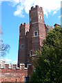
Buckden Towers
Formerly known as Buckden Palace, this is a 12th century fortified manor house,
It was used to house the Bishops of Lincoln. The tall brick tower was added in 1475, protected by walls and a moat, and surrounded by an outer bailey. It was used by the bishops until 1842. More recently it has been used as a Christian Retreat and Conference Centre.
Image: © Eirian Evans
Taken: 8 Apr 2009
0.13 miles
5

The Great Tower
Buckden Towers - formerly Buckden Palace, the house of the Bishop of Lincoln, as seen from St Mary's Churchyard.
Image: © Eirian Evans
Taken: 8 Apr 2009
0.13 miles
6

Bus stop and shelter, Hardwick
Just off the A1.
Image: © JThomas
Taken: 4 Jun 2015
0.14 miles
7

Buckden: entrance to the yard of a former coaching inn
This house, on what was originally The Great North Road, was once The Spread Eagle Inn. For its Grade II listing, see http://www.britishlistedbuildings.co.uk/en-54312-spread-eagle-public-house-buckden-cambrid#.VWX3VSiwHZY .
Image: © John Sutton
Taken: 27 May 2015
0.14 miles
8

Gatehouse, Buckden Towers
The manor belonged to the Bishops of Lincoln, and the palace was built in the 13th century. It is now a Christian retreat and houses the Catholic Parish Church of St Hugh of Lincoln.
Image: © Eirian Evans
Taken: 8 Apr 2009
0.14 miles
9

Buckden: the former Spread Eagle Inn
An eighteenth-century coaching inn on Buckden High Street, originally The Great North Road. For its Grade II listing, see http://www.britishlistedbuildings.co.uk/en-54312-spread-eagle-public-house-buckden-cambrid#.VWX3VSiwHZY .
Image: © John Sutton
Taken: 27 May 2015
0.14 miles
10

High Street Hardwick at the junction of the A1
Image: © David Howard
Taken: 13 Jan 2018
0.15 miles