
IMAGES TAKEN NEAR TO
York Yard, High Street, ST. NEOTS, PE19 5TB
Introduction
This page details the photographs taken nearby to York Yard, High Street, PE19 5TB by members of the Geograph project.
The Geograph project started in 2005 with the aim of publishing, organising and preserving representative images for every square kilometre of Great Britain, Ireland and the Isle of Man.

There are currently over 7.5m images from over14,400 individuals and you can help contribute to the project by visiting https://www.geograph.org.uk
Image Map
Images are licensed for reuse under creativecommons.org/licenses/by-sa/2.0
Notes
- Clicking on the map will re-center to the selected point.
- The higher the marker number, the further away the image location is from the centre of the postcode.
Image Listing (165 Images Found)
Images are licensed for reuse under creativecommons.org/licenses/by-sa/2.0
Image
Details
Distance
1

Buckden High Street
This was once The Great North Road, which, now the A1, bypasses Buckden. Many of the houses are Grade II listed.
Image: © John Sutton
Taken: 27 May 2015
0.03 miles
2
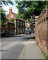
Buckden: High Street and Palace wall
The wall on the right once protected the Palace of the Bishop of Lincoln, now Buckden Tower, the home of the Claretian Missionaries.
Image: © John Sutton
Taken: 27 May 2015
0.03 miles
3

High Street, Buckden
This is the old A1 road, northwards from the entrance to 'The Towers'.
Image: © Humphrey Bolton
Taken: 13 Mar 2017
0.03 miles
5

High Street, Buckden
The High Street is dominated by this great brick wall for Buckden Towers.
Image: © Eirian Evans
Taken: 8 Apr 2009
0.05 miles
6

High Street
Looking south along what was once The Great North Road by the outer gatehouse to Buckden Towers
Image: © Richard Croft
Taken: 14 Mar 2008
0.05 miles
7

Buckden: the former Spread Eagle Inn
An eighteenth-century coaching inn on Buckden High Street, originally The Great North Road. For its Grade II listing, see http://www.britishlistedbuildings.co.uk/en-54312-spread-eagle-public-house-buckden-cambrid#.VWX3VSiwHZY .
Image: © John Sutton
Taken: 27 May 2015
0.06 miles
8

Buckden: entrance to the yard of a former coaching inn
This house, on what was originally The Great North Road, was once The Spread Eagle Inn. For its Grade II listing, see http://www.britishlistedbuildings.co.uk/en-54312-spread-eagle-public-house-buckden-cambrid#.VWX3VSiwHZY .
Image: © John Sutton
Taken: 27 May 2015
0.06 miles
9

Outer gateway and boundary wall, Buckden Palace
Largely of the fifteenth century https://historicengland.org.uk/listing/the-list/list-entry/1161771?section=official-list-entry
Image: © Jonathan Thacker
Taken: 30 Apr 2022
0.06 miles
10

Outer gateway, Buckden Palace
Dates from the late fifteenth century when Buckden Palace was a residence of the Bishop of Lincoln https://historicengland.org.uk/listing/the-list/list-entry/1161771?section=official-list-entry
Image: © Jonathan Thacker
Taken: 30 Apr 2022
0.06 miles